| |||||||||||||||||||||||||||||||||||
| |||||||||||||||||||||||||||||||||||
CHAPTER IV
METHODOLOGY
SITE INSTRUMENTATION AND DATA COLLECTION
In order to determine conveyance losses in a reach using the J349 conveyance loss computer model, it is necessary to have stream flow data on the reach in question as well as flow records from the major diversions or tributaries along that reach.
Greybull River Study Reach
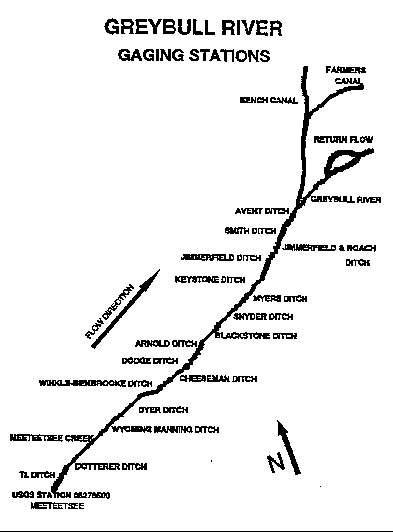
Along the Greybull River study reach, there were a total of twenty-two gaging stations installed to monitor flow and diversions. Each station was fitted with a stilling well, recorder stand, staff gauge and a continuous stage recorder. Two types of recorders were used in this survey, the Stevens Type F and the Stevens Type A-35. A table of recorders, and their locations on the reach are presented in Table 1. The purpose of these gaging stations was to accurately measure (using the mid-section method described in Rantz, et.al. (1983)) the amount of surface water flowing past that point. Figure 2 illustrates gaging station locations along the Greybull River.
TABLE 1
DESCRIPTION OF GREYBULL RIVER STREAMFLOW GAGING STATIONS
	Recorder Location		Control Section		Recorder
__________________________________________________________________________________
	USGS Station  			06276500		Natural
	T Ditch				2 foot Parshall		Type F
	Dotterer Ditch			18 inch Parshall	Type F
	Meeteetsee Creek		Natural			Type F
	Wyoming Manning Ditch		18 inch Parshall	Type F
	Winkle-Benbrooke Ditch		18 inch Parshall	Type F
	Dyer Ditch			3 foot Parshall		Type F
	Cheeseman Ditch			3 foot Parshall		Type F
	Dodge Ditch			2 foot Parshall		Type F
	Arnold Ditch			4 foot Parshall		Type F
	Myers Ditch			2 foot Parshall		Type F
	Snyder Ditch			2 foot Parshall		Type F
	Blackstone Ditch		Natural			Type F
	Keystone Ditch			4 foot Parshall		Type F
	Jimmerfield Ditch		4 foot Parshall		Type A-35
	Jimmerfield & Roach Ditch	3 foot Parshall		Type A-35
	Smith Ditch			18 inch Parshall	Type A-35
	Avent Ditch			3 foot Parshall		Type F
	Greybull River			Natural			Type F
	Return Flow			8 foot Parshall		Type F
	Farmer's Canal			20 foot Parshall	Type A-35
	Bench Canal			20 foot Parshall	Type A-35
__________________________________________________________________________________
Once the network of gaging stations was installed, rating curves were developed for each of the locations where a stream cross-section was required (using the methods in Rantz, et.al. (1983)). On canal diversions where Parshall Flumes were present, the flumes theoretical rating curve was used. Flow measurements were made with a current meter at each of the diversions to compare a gaged flowrate to the calibrated flow of the Parshall Flumes rating curve. All current meter flow measurements were found to be within ten percent of the calibrated flow values.
The recorders were in operation for the late summer of 1992 and spring of 1993.
Figure 2. Gaging Stations on the Greybull River Study Reach.
Wind River Study Reach
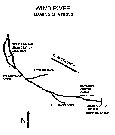
Along the Wind River study reach, a total of six gaging stations were in operation. Four of these stations were operated in cooperation with the Wyoming State Board of Control and the USGS and two of these stations were operated for the Shoshone and Arapahoe Indian Tribes by the USGS. Table 2 lists each canal and the operator. Figure 3 shows a schematic of the reach and its diversions. Both the Board of Control and the Shoshone and Arapahoe Indian Tribes were responsible for placement and supervision of their gaging stations. Surface flow records for the spring, summer and fall of 1992 were received for analysis from each organization.
DATA REDUCTION
Greybull River Study Area
TABLE 2
WIND RIVER CANAL OPERATORS
     	STATION 			OPERATOR
__________________________________________________________________________________
	Station 086276500		USGS (for Board of Control)

	Johnstown Canal			USGS (for Shoshone and Arapahoe Tribes)

	LeClair Canal			Board of Control

	Lefthand Ditch			USGS (for Shoshone and Arapahoe Tribes)

	Wyoming Central Canal		Board of Control

	Station 0622800			USGS (for Board of Control)
__________________________________________________________________________________
The process of reducing the streamflow data involved reduction of the charts from each of the gaging points in the study area. The data were reduced into two hour water stage increments. This time increment was selected to keep the increments smaller than the flood wave time of travel for the reach. These stage values were placed on a spreadsheet where an equation for the proper size of Parshall Flume for each diversion was applied to the stage data to obtain a flowrate. When the data came from a section without a flume, a rating curve was developed and applied to the spreadsheet stage values to obtain flowrates.
Figure 3. Gaging Stations on the Wind River Study Reach.
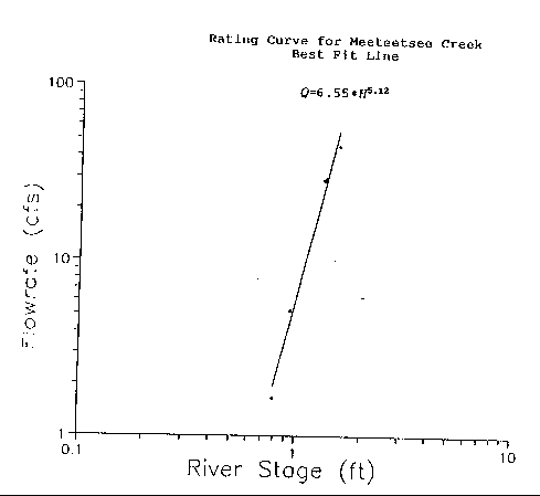
one method for developing a rating curve is to plot river stage versus measured discharge on a log-log graph. An equation of the form
Q = k * Hb
can be developed to fit the plotted data where:
Q = Discharge (cubic feet per second),
k = Coefficient,
H = Water stage (feet), and
b = Exponent.
A rating curve for Meeteetsee Creek is shown on Figure 4.
Wind River Study Area
The continuous streamflow data for the Wind River study reach provided by the United States Geological Survey were reduced by them and made available through the Wyoming Water Resources Data Group at the University of Wyoming's Water Resource Center. Charts for the LeClair Canal and the Riverton Valley Canal were provided by the State Board of Control and were of the A-35 continuous stage type. These charts were reduced in the same manner as the Greybull River charts on an hourly basis for water stage levels. These water stage levels were applied to rating curves developed by the Board of Control to obtain discharge values.
Figure 4. A Rating Curve for Meeteetsee Creek.
ADDITIONAL DATA NEEDED
In order to run the J349 program, additional information was required. The additional information includes:
flood travel time for the reach,
aquifer transmissivity,
storage coefficient,
wave dispersion coefficient,
wave celerity,
length of channel,
and length of alluvium.
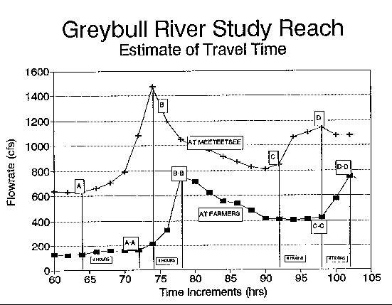
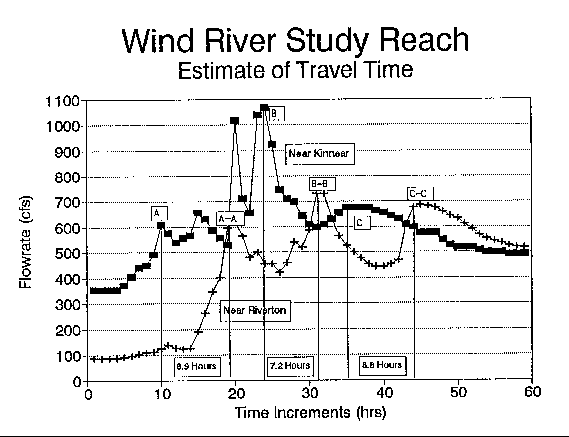
Travel time was determined by subtracting when a flood wave reached the beginning of the study reach from when the same flood wave reached the end of the reach using river stage data collected from the recorder charts to determine these times. Figure 5 shows a plot of flood wave travel on the Greybull River. Point A on the plot represents the point at which the flood wave reaches the upstream gaging station. Point A-A represents the point where the same flood wave reached the downstream gaging station. Points B and B-B represent the point of the peaks of the flood wave at the respective stations.
Points C:C-C and D:D-D represent similar points for other flood waves. From the plot, it can be seen that the flood wave time of travel is dependent on the magnitude of the flood wave. An average time of travel of eight hours was selected for the Greybull River after analysis of several flood waves. Figure 6 represents a similar plot of flood wave travel time for the Wind River. An average travel time of eight hours was selected from analysis of the data for the Wind River.
Figure 5. Greybull River Water Wave Travel Time Representation.
Aquifer transmissivity and storativity were determined for the study area during model calibration. Length of channel and length of alluvium give the model a measure of channel sinuosity and were determined from USGS 7.5 minute quadrangle maps using a digitizer. Wave celerity and wave dispersion were determined from methods detailed by Farber (1992).
Figure 6. Wind River Water Wave Travel Time Representation.
MODEL CALIBRATION
Field data were input into the J349 model following the input structure provided by the USGS for the model. The input structure as well as an example input and output for a trial run on the Greybull River are presented in Appendix A. The calibration process involved varying transmissivity, storativity, wave dispersion coefficient, wave celerity and base flow until predicted downstream discharge calculated by the J349 program simulated actual discharge at the downstream point.
94-05 Table of Contents
Water Resources Publications List
Water Resources Data System Library |
Water Resources Data System Homepage