| |||||||||||||||||||||||||||||||||||
| |||||||||||||||||||||||||||||||||||
James J. Jacobs, Professor, Agricultural Economics,
Department of Agricultural Economics,
College of Agriculture,
University of Wyoming
Donald J. Brosz, Associate Director,
Wyoming Water Resources Center,
University of Wyoming
Issued in furtherance of Cooperative Extension work, acts of May 8 and June 30, 1914, in cooperatin with the U.S. Department of Agriculture, Jim DeBree, Director, Cooperative Extension Service, University of Wyoming, Laramie 82071.
Persons seeking admission, employment, or access to programs of the University of Wyoming shall be considered without regard to race, color, national origin, sex, age, religion, political belief, disability, or veteran status.
Wyoming is situated astride the Continental Divide, and as a result provides the headwaters for four major river basins in the western United States. These major river basins are the Missouri-Mississippi, Green-Colorado, Snake-Columbia, and Great Salt Lake. Wyoming's location in relation to these four major river basins is depicted in Figure 1.
The Yellowstone, Wind, Bighorn, and Shoshone rivers in northwestern Wyoming; the Tongue, Powder, Belle Fourche, Cheyenne, and Niobrara rivers in northeastern Wyoming; and the North Platte and Laramie rivers in southeastern Wyoming are all headwaters of the Missouri-Mississippi River Basin. Approximately 72 percent of Wyoming's land area drains into and is part of the headwaters of the Missouri-Mississippi River Basin.
The Green and Little Snake rivers in southwestern and southcentral Wyoming are part of the headwaters of the Colorado River. The Green-Colorado River Basin drains about 17 percent of Wyoming's land area.
The Bear River along the southwestern border of Wyoming drains into the Great Salt Lake Basin. The land area that drains into the Great Salt Lake Basin represents about 2 percent of Wyoming's total.
Figure 1. Wyoming - Headwaters to the Major River Systems of the Western United States.
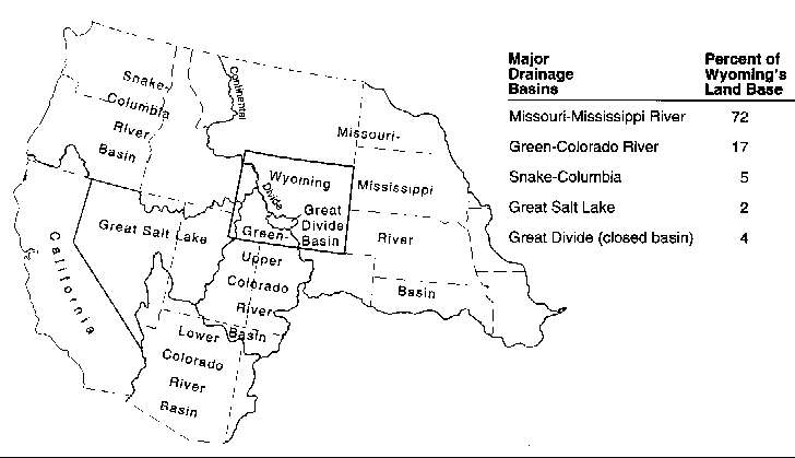
The Snake and Salt rivers, along the Idaho border in northwestern Wyoming, are part of the headwaters for the Snake-Columbia River Basin. Approximately 5 percent of Wyoming's land area is drained by the Snake-Columbia River Basin.
In addition to these four major river basins, about 4 percent of Wyoming's land area is in the Great Divide closed basin. This area is part of the Red Desert west of Rawlins.
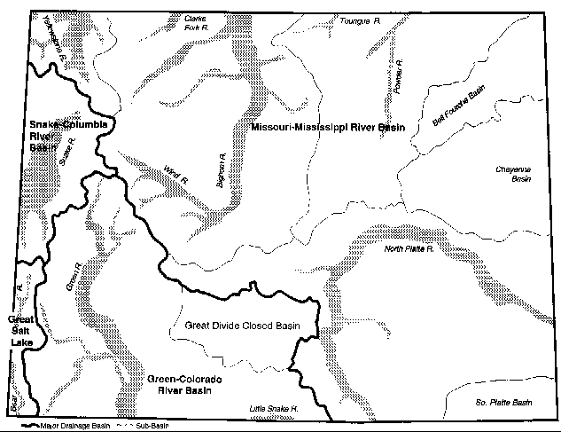
The major river basins discussed above, and some of the larger rivers in those basins, are shown in Figure 2.
Figure 2. Major Rivers of Wyoming.
WATER QUANTITIES
Surface Water
On average, about 16.3 million acre-feet of surface water are produced each year by precipitation on Wyoming's land area (1 acre-foot is 1 foot of water covering 1 acre of land, and equals approximately 326,000 gallons). Approximately 70 percent of Wyoming's surface water supply comes in the form of snow. On average, another 1.9 million acre-feet of water flows into the state each year. Streams that bring water into the state include the Laramie and North Platte rivers in southeastern Wyoming; the Little Snake River in southern Wyoming; the Blacks Fork, Henry's Fork and Bear rivers in southwestern Wyoming; and the Clarks Fork River in northwestern Wyoming. This gives a total annual surface water supply of about 18.2 million acre-feet. Through interstate compacts and court decrees, Wyoming may legally consume 6.4 million acre-feet of this surface water annually.
Groundwater
Groundwater can be found throughout the state, and a substantial amount of groundwater is available for future use. In terms of storage, it is estimated that there are 10 million acre-feet in alluvial aquifers and 3 billion acre-feet in bedrock aquifers. However, its use in the future depends on the cost of recovery and the decision whether to mine the resource or to limit use to the recharge rate. While large quantities of water are stored in alluvium and bedrock (consolidated sediment) formations, average annual recharge (the quantity of water entering these aquifers) is estimated to be 1 to 4 million acre-feet per year, respectively.
WATER USE IN THE STATE
Consumptive Uses
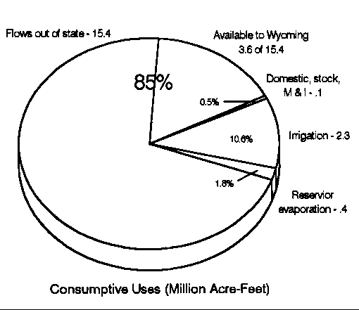
Consumptive use refers to the quantity of water evaporated, transpired, and/or incorporated into the products produced in connection with vegetative growth, food and industrial processing, and municipal use. Irrigation is by far the largest consumptive use of water in the state. Average annual consumptive use of surface water in irrigated agriculture is estimated to be 2.3 million acre-feet. Approximately 300,000 acre-feet of groundwater is also consumed by irrigated agriculture each year.
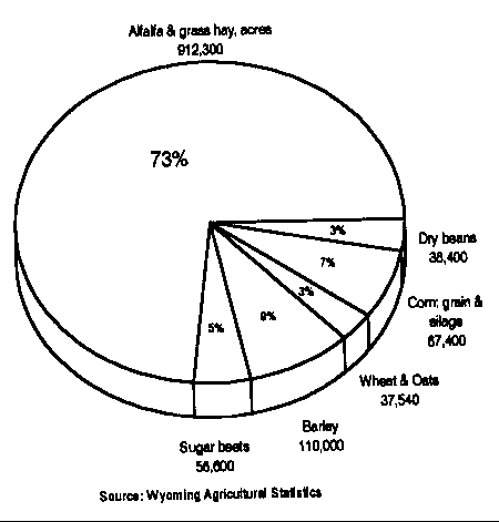
As in all western states, Wyoming's irrigated agriculture accounts for 80 to 85 percent of the consumptive use in the state. Approximately 60 percent of the farms and ranches in Wyoming irrigate. Wyoming's irrigated cropland acreage varies between 1.2 and 1.6 million acres from year to year, depending upon available surface water supplies. Average distribution of irrigated cropland by crop for 1986-1990 is shown in Figure 3 (Wyoming Agricultural Statistics).
Figure 3. Irrigated Acres by Crop.
It is also interesting to note that the second largest affect one or more of the four primary attributes of consumptive use is evaporation from reservoirs, which amounts to about 400,000 acre-feet annually. All other water users in Wyoming (municipal, domestic, livestock, and industrial) consume approximately 60,000 acre-feet of surface water and 100,000 acre-feet of groundwater annually.
The above consumptive uses result in an average depletion of about 2.8 million acre-feet of surface water supplies. Thus, on an average, 15.4 million acre-feet of surface water flows out of Wyoming into neighboring states each year. These consumptive uses of surface water are summarized in Figure 4.
Figure 4. Wyoming's Surface Water Resources.
Non-Consumptive Uses
Non-consumptive uses include those uses where water is not consumed by the use such as recreation on streams and lakes, hydropower generation, fisheries in streams and lakes, and return flows from irrigated agriculture, industry, or municipality. As a result, much of the water flowing out of the state is used in Wyoming in a non-consumptive way as it flows in our streams.
The terminology of consumptive and non-consumptive use of water is a very important concept in managing water resources. This terminology can be used to illustrate the four main attributes of a water supply: (1) quantity, (2) quality, (3) location, and (4) timing. As individuals or communities withdraw water, they generally consume part of the water and return part of it to the stream and/or groundwater. This generally means that for each withdrawal of water, that part of the use that is non-consumptive is returned to a stream and/or groundwater. However, each water use is likely to affect one or more of the four primary attributes of water (quantity, quality, location, and timing). This in turn may affect subsequent uses of water because water is continually on the move (flowing). These attributes and the nature of water have to be considered in planning for and using the state's water resources.
RESERVOIR STORAGE
As indicated earlier, approximately 70 percent of Wyoming's water supply comes in the form of snow. Snowmelt occurs from March through June, and early July. Reservoir storage plays a very important role in Wyoming by holding water supplied from snowmelt and making it available during summer and fall, which are times of limited precipitation and heavy demand. Major storage reservoirs in Wyoming and storage capacities are shown in Table 1.
WATER RIGHTS
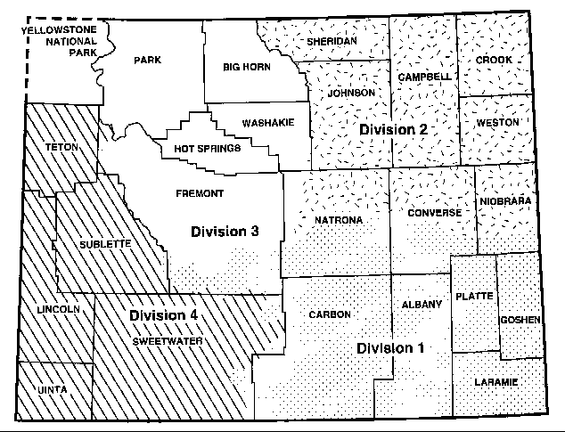
The Wyoming Constitution declares that the waters of all natural streams, springs, lakes, or other collections of still water within the boundaries of the state are the property of the state. Constitutional provisions allow for the appropriation of water for beneficial use and established the Office of the State Engineer and Board of Control to supervise such appropriations. The Board of Control includes the State Engineer (president) and the superintendents of each of the state's four administrative water divisions. These water divisions are shown in Figure 5. The State Engineer has general supervision of the waters of the state and its distribution.
Table 1. Names and Sizes of Reservoirs in Wyoming
---------------------------------------------------------------------------------
	River System	Reservoir	Storage Capacity

	North Platte	Seminoe		       1,017,000
	North Platte	Kortes	       	           4,740
	North Platte	Pathfinder	       1,017,000
	North Platte	Alcova		         184,000
	North Platte	Glendo		  	 517,000
	North Platte	Gurnsey		   	  46,000

	Laramie	        Wheatland No. 2		  98,000
	Laramie	        Wheatland No. 3	          80,000
	Laramie	        Greyrocks		 104,000

	Belle Fourche	Keyhole		  	 340,000

	Wind/Big Horn	Bull Lake	  	 153,000
	Wind/Big Horn	Boysen		  	 802,000
	Wind/Big Horn	Yellowtail	       1,375,000

	Shoshone	Buffalo Bill	   	 695,300

	Powder	        Lake DeSmet	  	 239,000

	Snake	        Jackson Lake	     	 847,000
	Snake	        Palisades	       1,401,000

	Green	        Big Sandy	   	  39,700
	Green	        Fontenelle	         345,000
	Green	        Flaming Gorge	       3,788,700

	Bear            Woodruff Narrows          57,000
	Bear            Sulphur Creek             19,600
---------------------------------------------------------------------------------
State statutes establish the procedure for the appropriation of water for beneficial use. First, a permit to use water must be obtained from the State Engineer. After the water has been put to use and proof of beneficial use is made to the Board of Control, the board will adjudicate the water right. Priority of appropriation is based upon the date applications for permits were received in the State Engineer's Office. "First in time is first in right" is the basis of Wyoming water law.
Within Wyoming's water laws, one aspect that receives considerable emphasis is water transfers. It is possible to transfer water to an alternative use if it is to a preferred use. The preferred uses of water recognized in Wyoming water law are:
The transfer of a water right to a preferred use is initiated by filing a petition requesting to make a change with the State Board of Control. The petition should present all of the facts regarding the existing use and the proposed change in use. The board will review all the facts and may allow the transfer provided that it does not in any way injure other existing lawful appropriators. For a more complete summary of Wyoming water law see Bulletin B-849 R, Cooperative Extension Service, University of Wyoming, Laramie.
INTERSTATE WATER RIGHTS
Although the Wyoming Constitution declares water to be the property of the state, Wyoming is limited in the amount that streamflows can be depleted by interstate water compacts established with other states and by court decrees.
The state's leaders realized many years ago that downstream states developing faster than Wyoming might establish prior water rights that could stifle future Wyoming development. Interstate compacts are agreements allocating the water of an interstate stream among states and were negotiated on most of Wyoming's streams. The rights of states to the waters of some interstate streams have been settled by decrees of the courts of the United States.
The rights of Colorado and Wyoming to the waters of the Laramie River and the rights of Colorado, Wyoming, and Nebraska to the waters of the North Platte River have been established by decrees of the U.S. Supreme Court. The rights of Wyoming and Idaho to the waters of Teton Creek and South Leigh Creek have been established by a decree of the District Court of the United States for the District of Wyoming. Wyoming's rights to the waters of the Bear, Belle Fourche, Colorado (Green River, Little Snake River, Henrys Fork of the Green River), Niobrara, Snake, and Yellowstone rivers (Clarks Fork of the Yellowstone River, Wind/Big Horn River, Tongue River) have been apportioned by interstate compacts.
Wyoming can also be affected by international treaties where some of the water that rises in Wyoming eventually finds its way to another country. This is the case with the international treaty between the US and Mexico on the Colorado River, of which the Green River is a major tributary.
Figure 5. Administrative Water Divisions of Wyoming.
Water allocation, through compact agreements between the states, was done by dividing on a percentage basis the unused and unappropriated flows of the respective streams. Unappropriated waters available to Wyoming annually for consumptive uses from various streams are given in Table 2.
The compacted water quantities total approximately 3.6 million acre-feet of surface water supplies that still remain for Wyoming's future annual consumptive uses out of the total 15.4 million acre-feet now flowing out of the state. There is also a limited quantity of water available from streams that are not compacted.
POTENTIAL USES OF WATER
Irrigated Cropland
As indicated earlier, irrigation is by far the largest consumptive use of water in the state. However, future development of water for irrigation purposes (both surface and groundwater) will depend primarily on economics and the political process. Most of the better irrigation projects have been developed and remaining potential surface water development includes bench lands some distance from the streams. Groundwater development potential is somewhat difficult to estimate because of the very limited information available on depths, quantity, and quality of this source of water.
Municipal and Domestic
Approximately 30 percent of the municipal population uses surface water as its source of water supply, 25 percent uses groundwater, and the remaining 45 percent uses a combination of surface and groundwater. Those who do not reside in a municipality have their own private domestic water supply systems. Very little data are available on private domestic water uses in the state.
Municipal, domestic, and stock water uses are projected to increase from the estimated current depletion of about 60,000 acre-feet to 148,140 acre-feet per year by the year 2020 (The Wyoming Framework Water Plan, 1973).
Table 2. Unappropnated Waters in Wyoming Available for Consumptive Use.
------------------------------------------------------------------------------------------------------------------------------------
		              Acre-Feet
	River System 	      Available	    Comments

	Clarks Fork	        424,000
	Wind/Big Horn	      1,600,000	    Indian water rights	being settled.
	Tongue	                 94,000
	Powder	                165,000
	Belle Fourche	          7,000
	North Platte	              0	    Fully appropriated
	Green/Little Snake	455,000
	Snake	                150,000
	West Teton Tributaries	355,000	    Only part is available for use in Wyoming-some minimum
 	                                    flow must enter Idaho. Based on 1980 Compact
	Bear	                  1,073

	Non-compacted Rivers

	Yellowstone	      2,700,000	    Not likely to be used in Wyoming because of location.
	Little Big Horn	        114,000
	Little Missouri	         31,000
	Cheyenne	         58,000
------------------------------------------------------------------------------------------------------------------------------------
Industrial
Wyoming's industry currently depletes the state's water supply by approximately 85,000 acre- feet. Of the amount of water used by industry, about two-thirds of it comes from groundwater supplies. Industrial water needs are projected to be 845,000 acre-feet per year by the year 2020 (The Wyoming Framework Water Plan, 1973). Most of the projected increase in water consumption was to be by the coal industry, which has not grown to the point projected in the early 1970s.
Hydropower
An important non-consumptive use of Wyoming's water is hydroelectric power generation. Major hydroplants in or adjacent to Wyoming and their generating capacities are:
The present hydroelectric generating capacity on Wyoming rivers is 684,300 kilowatts.
Recreation
Water-based recreation, largely a non-consumptive use, is another important use of the state's water resources. Based on a survey conducted in 1990, rivers and streams provide about 1.6 million fishing-days of use per year and standing waters provide nearly 2 million fisherman-days a year. It is estimated that fishing pressures could increase to 1.75 million and 2.14 million fisherman-days on streams and still water, respectively (The Wyoming Framework Water Plan, 1973). In addition, Wyoming waters are used for boating, skiing, aesthetic, and other recreation and leisure purposes.
WATER PLANNING AND DEVELOPMENT
State Engineer's Office
Constitutional provisions allow for the appropriation of water for beneficial uses. As previously discussed, Wyoming water law is based on the doctrine of prior appropriation, meaning the first in time is first in right. The State Engineer is the chief administrator of the water resources in Wyoming. Thus, procedures for obtaining a legal water right and administration of all associated water laws, including those for interstate water, are administered through the State Engineer's Office.
Inquiries may be directed to the State Engineer's Office, Herschler Building, Cheyenne, Wyoming 82002.
Wyoming Water Development Commission
The Wyoming Water Development Commission was established in 1979. The commission includes ten members appointed by the Governor with three advisory members, including the State Engineer, a representative from the University of Wyoming appointed by the President, and a representative of the Economic Development and Stabilization Board. The commission is administered by a director and staff.
The commission serves as the water development and planning agency, and administers new development, construction, and rehabilitation for both surface water and groundwater. The commission generates and assembles the necessary data for prioritizing by commission members and a Select Legislative Water Committee. Money for the water development program comes from designated taxes on coal, oil, and gas.
Inquiries may be directed to the Wyoming Water Development Commission, Herschler Building, Cheyenne, Wyoming 82002.
Department of Environmental Quality
The Department of Environmental Quality (DEQ) was created in 1973. DEQ is designated as the regulatory agency responsible for enforcing the Wyoming Environmental Quality Act, which includes water quality regulation. Administration of water quality issues are addressed by the Water Quality Division within DEQ.
DEQ operates under the guidance of an Environmental Quality Council. The council is comprised of seven private citizens appointed by the Governor. Each division within DEQ, such as the Water Quality Division, has a separate advisory council.
The Federal Water Pollution Act Amendment of 1972 (PL-92-500), under Section 208, provides the authority to plan and manage water quality by state and local governments. A 208 plan provides the opportunity to tie together the "point" and "nonpoint" sources of pollution through a single management scheme. The plan identifies water quality problems and alternative management practices for addressing the identified water quality problems, sets priorities and timetables for implementation of the best management practices, and identifies institutional organizations for carrying out the water quality programs in the state.
The DEQ Water Quality Division is carrying out the provisions of the Federal Water Pollution Act. Through its council, plans are being developed to address Wyoming water quality problems. Wyoming has developed a State Water Quality Plan, which has been certified by the Governor and approved by the U.S. Environmental Protection Agency, upon which water quality planning is proceeding in the state.
Inquiries regarding water quality can be addressed to the Department of Environmental Quality, Water Quality Division, Herschler Building, Cheyenne, Wyoming 82002.
State Water Forum
There are several state and federal agencies involved and interested in the state's water resources. To update each other and coordinate water programs, representatives from both state and federal agencies meet once a month. The forum is chaired by the State Engineer. In addition to agency updates, a special report on a selected water issue and/or program of current interest or concern is given at each monthly meeting.
SUMMARY
Water concerns cut across all lines; it's important to agriculture, municipalities, industries, recreation, and people. Water is an important factor in the social and economic growth of any community, and for the state itself. Thus, the wise development, use, and management of this precious resource is essential.
It was indicated earlier that the state has approximately 3.6 million acre-feet of surface water that could be consumed annually. Wyoming citizens are concerned about the economic effects of allowing unappropriated surface waters to leave the state. To develop this water, state water development officials need reliable information on the benefits that would be generated by the major water dependent sectors of agriculture, coal-energy industry, and recreation. The state agencies and the University of Wyoming need to work together in developing a framework in which development benefits and costs of using water in the three major water dependent sectors can be computed and compared. This would provide the basis for establishing water development priorities and a sound water development policy.
Water Resources Publications List
Water Resources Data System Library |
Water Resources Data System Homepage