| |||||||||||||||||||||||||||||||||||
| |||||||||||||||||||||||||||||||||||
APPENDIX A
WYOMING'S WEALTH OF WATER RESOURCES AND SCARCITY ELSEWHERE
A.1 INTRODUCTION
This appendix addresses the following issues: (1) water availability, water use, and water entitlements for Wyoming; and (2) potential scarcity in other states. The motivation for the investigation can be found in our attempt to understand Question 1 in the introduction: What are the forces driving the water development program? As it will hopefully become clear in reading through the appendix, Wyoming has an abundance of water for now and for needs in the near future. However, other states and in particular the downstream basin states, do not have an abundance of excess water now. It was this juxtaposition of abundance and downstream scarcity that interested us. A further motivation for the subject matter of this appendix was to lay the groundwork for the survey of Wyoming residents.
A.2 WYOMING'S WATER AVAILABILITY, WATER USE AND WATER ENTITLEMENTS
Wyoming is separated into four administrative water divisions. The first three of these divisions contain headwaters of the Missouri River. Water Division #l includes the Niobrara River, the North Platte River, and the South Platte River drainages; Water Division #2 includes the Tongue River, the Powder River, the Belle Fourche River, the Little Missouri River, and the Cheyenne River drainages; and Water Division #3 includes the Clarks Fork River, the Bighorn River, and the Little Bighorn River drainages. For the purposes of this appendix, the Yellowstone River and its tributaries are included in Water Division #3, although their water is not available for use in Wyoming for geographical as well as legal reasons. Finally, Water Division #4 includes headwaters of three river basins: (1) the Little Snake River and the Green River, which run into the Colorado River Basin; (2) the Bear River, which flows into the Great Salt Lake Basin; and (3) the Snake River and the West Teton tributaries, which form part of the headwaters of the Columbia River Basin. (See Figure A.1 for an overview.)
Table A.1 describes water availability and water use by water division. The basis of this table is a similar table in an information leaflet from the Wyoming Water Planning Program (WWPP) from June 1972 (Wyoming State Engineer's Office [1972]). From the WWPP table, we reproduced columns (2), (3), and (4) directly, by simply adding up the figures of those rivers that belong to one water division. This assumes, that natural streamflow volume has not changed significantly since 1968. We also assumed that the total surface area of reservoirs in Wyoming did not change significantly during the same period, as well as all other factors that influence evaporation from reservoirs. Subsequently, we also retrieved the data for column (7) from the WWPP table.
Updating was necessary, though, for columns (5) and (6), which in turn changes the figures in columns (8) and (9). Since the necessary data for this procedure is available only for counties, the first step was, to relate the 23 counties in Wyoming to the four water divisions:
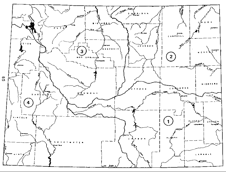
                          TABLE A.I

      Wyoming Average Annual Streamflows and Water Uses
          (Streamflow Base Period from 1948 - 1968;
                all figures in acre-feet/year)
________________________________________________________________

Water           Streamflow        Water Yield     State Line
Division	into Wyoming      within          Outflow under
		From Other        Wyoming         Natural
                  States                          Conditions
    (1)             (2)               (3)         (4)=(2)+(3)
________________________________________________________________

Div.No.1             530,000         1,240,500	  1,770,500
Div.No.2               ---           1,019,100	  1,019,100
Div.No.3             446,000         6,645,000	  7,091,000
Div.No.4             531,000         6,922,700	  7,453,700
                  __________        __________	___________

Wyoming            1,507,000        15,827,300   17,334,300


Man's Water Consumption in Wyoming                      Depleted
_________________________________________________       Streamflow
                                                        Leaving
Irrigation    Municipal   Reservoir    Total            Wyoming
                 &        Evaporation
              Industrial
     (5)         (6)          (7)       (8)             (9)=(4)-(8)
________________________________________________________________

  637,600        59,100       180,000     876,700      893,800
  140,400        13,900        66,000     220,300      798,800
1,086,700        15,200       106,000   1,207,900    5,883,100
  392,000       129,100        38,000     559,100    6,894,300
_________       _______       _______   _________   __________
2,256,700       217,300       390,000   2,864,000   14,470,300
________________________________________________________________
These assignments are naturally arbitrarily, because in most cases political boundaries do not follow watersheds. Therefore, we will only mention the three most significant problems:
After this preliminary step, the updating of column (5) could begin. Data on the amount of water used for irrigation in each county or water division was not available. But from the U.S. Census of Agriculture (U.S. Bureau of the Census [1972, 1977, 1984]), the irrigated acreage in each county was known for the years 1969, 1974, and 1982. The mean of the data from 1969 and 1974 was taken to represent the irrigated acreage at the time, when the WWPP table was compiled. This enabled us, to compute 1982 water consumption for irrigation for each water division by adding up the irrigated acreage of all counties within one water division and then using the following formula:
| 1982 irrigated acreage 1972 irrigated acreage | X 1972 water consumption for irrigation |
| = water consumption for irrigation |
The data for 1972 water consumption for irrigation is taken from the WWPP table. The results are shown in column (5).
To update the data for municipal and industrial water consumption two factors must be kept in mind: the growing population and the increasing water consumption per capita. To take care of the change in population, we retrieved data about the population of Wyoming counties in 1970 and 1980 from the Wyoming Data Handbook 1987 (Department of Administration and Fiscal Control [1987]) and transferred the county populations into water division populations, according to the assignment described above.
Adjusting the water consumption per capita was not straightforward. The U.S. Geological Survey (USGS) publishes water use data that includes per-capita use broken down to the state level every five years (Murray [1972]; Solley [1983]). Thus, we had to assume the same per-capita water consumption in all four water divisions. Unfortunately, the USGS breaks down municipal and industrial water use into four categories: (1) public supply, (2) rural domestic and livestock use, (3) thermoelectric power generation, and (4) other self-supplied industrial use. Further, water consumption is given only as total water consumption, containing ground water and saline water as well as fresh surface water, but water withdrawal is broken down into these categories. So, we assumed that the portion of fresh surface water in water consumption is the same than its portion in total water withdrawal. This assumption enabled the calculation of fresh surface water consumption in each of the four water user categories mentioned above. Table A. 2 shows the results of these calculations.
By dividing the numbers in Table A. 2 by the population in 1970 and 1980, respectively, we obtained the fresh surface water consumption per capita:
This represents a dramatic increase in water use per capita within a period of only ten years. This might be partly due to an inconsistency in the USGS data about water use for thermoelectric power generation in Wyoming. The water consumption figure jumps from 5.3 to 45 mgd over this ten year period, representing an 850 percent increase. The water withdrawal figure, however, increased only by ten percent during the same period. We had to use these inconsistent figures, because other figures were not available. This might explain a part of the dramatic increase in water consumption per capita. However, the data for public supply and for other
                         TABLE A.2

              Wyoming Surface Water Consumption
________________________________________________________________

                                 Fresh Surface Water Consumption
                                 In million gallons/day (mgd)
                                 ________________________________

Water Use Category                   1970              1980
________________________________________________________________

Public Supply                         6.12             32.20
Rural Domestic and Livestock Use     15.36             10.92
Thermoelectric Power Generation       5.3              45
Other Self-Supplied Industrial
Use                                   1.38              6.47

Total                                28.16             94.59
________________________________________________________________
self-supplied industrial use also increase drastically, which indicates that our results are not totally unrealistic.
The final calculation of the municipal and industrial (M&I) water consumption, as it appears in Table A.1, was done according to the following formula:
| 1980 population 1972 popilation | X 1970 M&I water consumption |
| =1980 M&I water consumption |
The results of this calculation, done for each water division, are shown in column (6).
The rest is straightforward: The updated columns (5) and (6) are added to column (7), which represents reservoir evaporation, which presumably did not change since 1968. These sums are shown in column (8) and represent man's depletion of streamflow. Column (8) subtracted from column (4) yields the depleted streamflow leaving Wyoming.
Table A.1 shows the quantity of water, that is flowing through and out of Wyoming. But not all of this water is available for consumptive use in Wyoming. Interstate compacts and court decrees regulate for most rivers, how much water Wyoming has to allow to cross its stateline. Table A.3 shows, how much more water Wyoming citizens could consume, in addition to the amount they are using now. This table is based on data made available by Donald J. Brosz, Extension Irrigation Engineer at WWRC. The numbers vary a little from those in the corresponding columns in the previous table, which is not surprising, given the randomness of stream flows during the years.
A.3 POTENTIAL SCARCITY IN OTHER STATES
There are at least two ways that the scarcity issue can be examined: (1) examination of water right prices, and (2)
                             TABLE A.3

                    Water Available to Wyoming
                       (in acre-feet/year)
________________________________________________________________
Stream                Yield       Outflow   Consump-  Legally
                      + Inflow              tive Use  Available
                                                      but Unused
________________________________________________________________
Yellowstone River    2,706,000  2,706,000       0            *
Clarks Fork River      716,000    690,000     26,000     424,000
Bighorn River        3,961,000  2,608,000  1,083,000   1,600,000
Little Bighorn R.      119,000    114,000      5,000        **
Tongue River           460,000    376,000     84,000      94,000
Powder River           434,000    338,000     96,000     165,000
Little Missouri R.      35,000     31,000      4,000        **
Belle Fourche R.        86,000     66,000     20,000       7,000
Cheyenne River          79,000     58,000     21,000        **
Niobrara River           7,000      3,000      4,000       ***
North Platte River   1,473,000    966,000    777,000       ***
South Platte River      20,000      7,000     13,000       ***
Little Snake River     404,000    385,000     19,000  )
                                                      )  455,000
Green River          1,882,000  1,536,000    346,000  )
Snake River          4,436,000  4,438,000     88,000     150,000
West Teton
     Tributaries       360,000    355,000      5,000         *
Bear River             431,000    343,000     88,000      13,000
Total               17,349,000 14,400,000  2,949,000   2,908,000
   *The water in the Yellowstone River and in the West Teton
    Tributaries is generally considered not available for use by
    Wyoming.  Reasons for this are geographical barriers and
    legal situations.  The Yellowstone River leaves the
    Yellowstone National Park in Montana and the West Teton
    Tributaries are separated from Wyoming by the Grand Teton
    National Park.

  **For the rivers that are not under compact agreements (the
    Little Bighorn River, the Little Missouri River, and the
    Cheyenne River) it is not exactly known how much additional
    water is available for use in Wyoming.

 ***Niobrara River, North Platte River and South Platte River are
    generally considered as fully appropriated.
projected depletions.28 In what follows two trends become obvious. First, water right prices have been increasing over time and will continue to increase. Second, basins will become depleted from individual state perspectives.
Water right prices have increased rather dramatically in the 1960 to 1980 time period. Table A.4 indicates that the value of water rights in Arizona increased from $708 to $750 per acre-foot in the 1970 to 1980 period. In southwestern Colorado, and in the Colorado Big-Thompson area, however, prices increased from $913 and $310 per acre-foot in the 1960s to over $2,000 and $3,000 per acre-foot, respectively, in the 1980s. The value of water rights in Nevada remained relatively constant during the 1960s and 1970s, but increased more than five-fold between the 1970s and 1980s. Prices for water rights in New Mexico increased from between $427 per acre-foot and $2,661 per acre foot in the 1960s to between $1,000 and $10,000 per acre-foot in the 1980s. Clearly Table A.4 suggests that water values in the western states are increasing significantly.
Water right prices can be expected to increase over time. Table A.5 presents a simple projection based upon the data presented in Table A.4. The estimates are based upon a geometric extrapolation of the increases that occurred in the 1970-1986 time period. While one cannot know the precise values from such a simple forecasting framework, the table does suggest that if the recent past is a predictor of the future that values will increase dramatically. As such, it is not difficult to infer that there will be increasing pressure on downstream states to find "new" water.
Turning to expected water deficits. Table A.6 presents a possible trend through the year 2030. Rapidly growing states
                         TABLE A.4

         Water Rights Prices in Selected Western States:
                   1960s Through 1980s
________________________________________________________________

                           $ Per Acre-Foot, 1985 Dollars____
                       1960s           1970s           1980s
________________________________________________________________

Arizona             $   NA          $  708          $  750

Colorado:
 Southwest             913           1,929           2,102
 Big Thompson          310           1,252           3,059

Nevada                 320             255           1,394

New Mexico             427-            853-          1,000-
________________________________________________________________

SOURCE:  Saliba, Bonnie Colby, David B. Bush, William E. Martin,
    and  Thomas  C.   Brown,   "Do  Water  Market  Prices
    Appropriately Measure Water Values?" Natural Resources
    Journal. 27(3) (Summer 1987), pp. 617-652, Table 2.

NA:      Not available
                          TABLE A.5

          Water Rights Prices in Selected Western States:
                     1990s through 2020
________________________________________________________________

                         1990s           2000            2020
                          ($ Per Acre-Foot;  1985 dollars)
________________________________________________________________

          (1980s)

AZ          850           784             820             925

CO:
 S.W.     2,102         2,682           3,421           5,605
 C-BT     3,059         5,978          11,683              NA

NV        1.394            NA              NA              NA

NM        1,000-        1,172-          1,269-          1,743-
         10,000        11,267          12,694          16,114
________________________________________________________________

Sources:  See Sources given in Table A.4.  Estimates for 2000-
2020 are extrapolations from mid-1980 values based on
geometric increases during the 1970-86 periods.

NA:       Not available
                          TABLE A.6

         Expected Water Deficits in Selected Western States
________________________________________________________________

          1990       2000        2010          2020       2030
(1,000 Acre-Feet)
________________________________________________________________

AZ       60-500       ----        ----         27-434	   ----

CAL       1,010      1,130        ----          ----       ----

COL           2       ----        ----             9       ----

KS          111         93        ----            76         64

OK          112       ----        ----            700       ----

TX       64-800       ----        ----      1,100-2,500     ----

UT         ----       ----        ----          ----      Starts
________________________________________________________________

Sources:  Arizona Water Commission [1977]; State of California,
[1983],  p.  79; State of Colorado and Bureau of
Reclamation [1974], p. 20; State of Kansas [1978], p.
79;  Oklahoma Water Resources Board  [1980],  p.  154,
155;  Texas  Department  of  Water  Resources  [1983],
Section 3; and State of Utah [1981], p. 15, for the
listed states, respectively.
such as Arizona and California can be expected to experience water deficits in the near future.
A.4 IMPLICATIONS OF WYOMING'S ABUNDANCE AND DOWNSTREAM DEFICITS FOR THE COLORADO BASIN
The implication of the water shortages expected in these states are apparent. If such shortages and high prices, in fact develop, economic activity in those states will potentially decline and the ability to attract new industry will also correspondingly decline. As such, these states may attempt to avoid shortages and attendant high prices by attempting to enhance their supplies from other sources through legal maneuvers. This point is developed from a legal perspective in Appendix E.
It would appear that Wyoming's relative abundance of water juxtaposed with the downstream shortage scenario would suggest that any methodology for evaluation Wyoming's proposed water projects would have to consider "controlling" Wyoming's water. The issue was explored in the specific context of the Watts, Brookshire, and Cummings [1989] report. In broadening the perspective developed in that effort, the survey reported upon in Chapter 4 and Appendix D attempted to broaden the perspective of Wyoming's potential loss of some of its water resources.
90-12 Table of Contents
Water Resources Publications List
Water Resources Data System Library |
Water Resources Data System Homepage