| |||||||||||||||||||||||||||||||||||
| |||||||||||||||||||||||||||||||||||
RESPONSE OF A SURFACE AQUIFER
TO FLOOD IRRIGATION
J. Wetstein and
V. Hasfurther
Conference Preceedings 1989 WWRC-89-32
In
Proceedings of the Specialty Conference
Sponsored by the
Irrigation and Drainage Division,
Water Resources Planning and Management Division,
and the
Delaware Section of the
American Society of Civil Engineers
J. Wetstein
V. Hasfurther
Wyoming Water Research Center
University of Wyoming
Laramie, Wyoming
In National Water Conference, Proceedings of the Specialty Conference sponsored by the Irrigation and Drainage Division and the Water Resources Planning and Management Division of the American Society of Civil Engineers and the Delaware Section of ASCE, University of Delaware, Newark, July 17-20, 1989 (T.A1 Austin, editor).
Response of a Surface Aquifer to Flood Irrigation
Abstract
The response of an unconfined alluvial aquifer, and associated stream system, to recharge by flood irrigation in the New Fork River valley in western Wyoming was studied. A water budget analysis, aided by the use of the United States Geological Survey groundwater model entitled "A Modular Three-Dimensional Finite-Difference Ground-Water Flow Model," was performed on the 28 square mile (73 square kilometer) study area. Results obtained from field data collection and operation of the model were return flows to the stream, change in aquifer storage, and the groundwater inflow minus groundwater outflow to the aquifer.
Introduction
Flood irrigation involves supplying water to an agricultural crop by completely saturating the upper surface area of said crop and in some instances saturating the alluvial aquifer and maintaining saturation until the crop is harvested. In the State of Wyoming, where water is a limited resource, the practice of flood irrigation has been questioned regarding the effects that this volume of stream diversion will have on the stream system. One area of special concern involves the return flow back into the channel network. It is essential to the dynamics of the system, and to the appropriated water rights holders downstream, that a significant percentage of the diverted water is returned to the stream channel and not lost to groundwater flow.
An alluvial aquifer artificially recharged by flood irrigation may act as an underground reservoir. The diverted water that is not consumptively used nor interacted with the stream system via return flows, is in effect being stored in an underground reservoir. This water is being stored without the expense of costly dam construction. Additional benefits associated with groundwater storage are (1) lower evaporation losses, (2) the land surface can still be put to a beneficial use, and (3) the slow release of the stored water during low flow months will allow for a more reliable source of water for downstream users during these months.
This paper presents a study of a surface alluvial aquifer located high on a large watershed in western Wyoming. The aquifer is subjected to flood irrigation and the stream system is heavily regulated resulting in a semi-flood free drainage system. The interaction of this stream-aquifer system over time and how it acts as an underground reservoir for maintaining instream flow through return flows was the main objective of the study.
Study Area
The New Fork River study area consists of a 28 square mile (73 square kilometer) unconfined alluvial aquifer, located in west-central Wyoming near the town of Pinedale. The aquifer ranges in thickness from zero feet (0 m) at the watershed boundaries, to approximately 40 feet (12 m) at its center. The surface aquifer is underlain by a fine grained unit of the Tertiary Wasatch formation which separates it from the lower regional aquifer. It is assumed that no significant interchange of water occurs between the alluvial and regional aquifers. The major stream that flows through the area is the New Fork River which transverses the area from the northwest corner to the southeast corner. A secondary stream of size within the study area is Willow Creek which flows along the eastern boundary of the study area in a north-south direction. There is a surface elevation drop of 270 feet (82.3 m) in approximately 9 miles (14.5 km) through the study area.
Regional topography is dominated by a series of benches stepping easterly out of the New Fork River valley toward the Wind River Mountain range. The terraces are comprised primarily of the Tertiary Wasatch formation and constitute the northern, western and southern borders of the study area. The eastern boundary is a terrace made up of glacial outwash debris, mainly gravels and sands. The glacial deposits originated from the series of glacial advances that occupied this region during the Pleistocene epoch.
Native hay is the dominant commercial crop within the study area. The fields are irrigated in early June, by recharging the alluvial aquifer until it is approximately full. The water capacity is maintained at this level for nearly a month, until the end of July, at which time the headgates on the ditches are closed and the water level in the aquifer allowed to drop for haying purposes. Once haying is completed, in early September, irrigation is resumed at a much less intense rate. This later period of recharge which lasts approximately two months, until the onset of winter, is primarily for stock watering and to prevent the alluvial aquifer water table from dropping too rapidly during the fall months.
Figure 1 shows the general outline of the New Fork River study area. The 20 foot (6.1 m) contours are drawn to show the basin slope.
Figure 1. New Fork River Valley Return Flow Study Area.
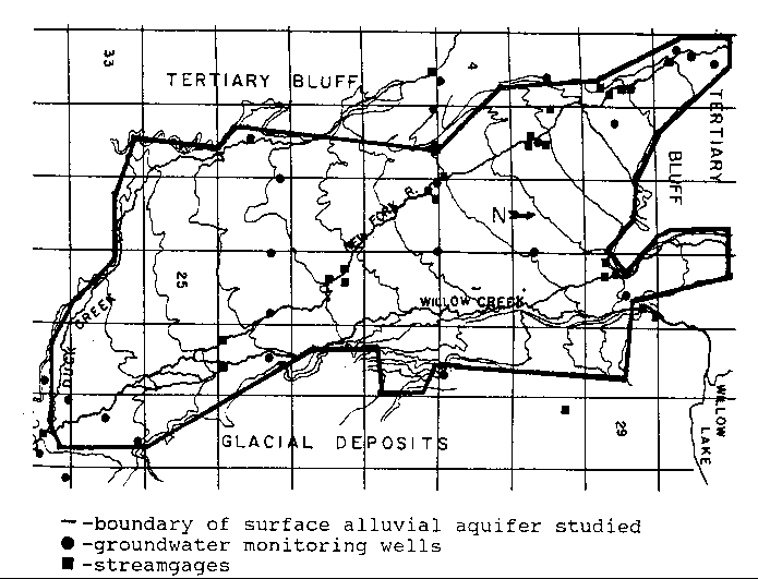
In order to evaluate the stream-aquifer interactions, a large field monitoring system was installed on the study area to allow a water budget analysis to be performed. Data acquisition was initiated in the spring of 1984 and concluded in the late summer of 1988. Streamgages, groundwater monitoring wells, precipitation gages, and staff gages were placed throughout the area, with lysimeters being utilized from a nearby study site.
A network of 31 Type F1 continuous recording streamgages manufactured by Leupold and Stevens, Inc. were established along the major and secondary streams and on most of the major diversion ditches located throughout the study area. These streamgages were activated in the early spring and left operational until late fall. A servomanometer stage recorder, that was operational year round, was located at the lower boundary of the study area. Rating curves were developed for all of the streamgages using the velocity-area method. Price AA and Pygmy current meters were used to measure stream velocity.
Evapotranspiration estimates were made from lysimeter data taken at a nearby site. The lysimeters were located near Daniel, Wyoming, 10 miles (16.1 km) west of the study area in an area with exactly the same type of vegetation cover, timothy grass, as in the study area.
Precipitation data were obtained from three raingages. A standard bucket-type raingage was installed near the center of the study area. Weather stations operated through the National oceanic and Atmospheric Administration recorded precipitation data for the rest of the study area. Station "Cora 4N" supplied data for the upper end of the study area and station "Pinedale" the lower end. Precipitation is applied to the study area using the Thiessen Polygon Method.
A grid of 27 wells located throughout the study area was utilized to monitor the water levels in an effort to determine storage response times of the aquifer. Twenty-five of the wells were installed at the beginning of the project. These wells were drilled and screened (8" hole and 4" pvc screen) the entire depth of the alluvial aquifer with the exception of the top five feet (1.5 m), which was cased with four-inch (.1 m) PVC pipe. The remaining two monitoring wells were existing water wells that were incorporated into the study. Well levels were measured weekly during the spring through the early fall period on the same day each week. Well levels were measured approximately monthly during the winter months. Transmissivity values were determined from constant-rate pumping tests. The drawdown was measured in the pumped well in all tests. The streamgage and groundwater monitoring well locations are shown on Figure 1.
A finite-difference groundwater flow modelling program was utilized in this study to determine the change in the storage of the aquifer and to separate out the percentage of diverted flow returning to the stream system as overland flow. The model that was selected for this study was the United States Geological Survey (USGS) model written by Michael McDonald and Arlen Harbaugh (1984). The model selection was based on an initial review of existing models that handle stream-aquifer interactions in a previous study done by Hilaire Peck (1985) for his master's thesis.
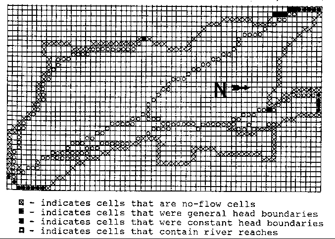
Figure 2 shows the finite difference grid used with the USGS model. The x's indicated on Figure 2 are the no-flow boundaries for the study area. The dimensions of each cell are 800 feet (243.84 m) by 800 feet. The total grid area is approximately 9.5 miles (15.4 km) long by 6 miles (10 km) wide. Model operation required several quantities to be input for each of the active cells in the model grid. These quantities were starting water level elevations, aquifer bottom elevations, specific yield, hydraulic conductivity, river stage elevations, river bottom elevations, river bed conductance, recharge rate, water level elevation in the constant head cells, and the conductance of the material between the constant head source and the associated general head boundary cell. The principle of the general head boundary involves a constant head source supplying water to the boundary cell at an assigned rate, controlled by the conductance of the interface between the source and the boundary. These values were measured in the field with the exception of the specific yield, aquifer bottom elevations, river bed conductance and the recharge rate. A specific yield of 0.2 was assigned which falls within the range of values generally accepted for an unconfined aquifer (Freeze and Cherry, 1979). The aquifer bottom elevations were obtained from monitoring well drill logs, and estimated where insufficient data existed. The river bed conductance was estimated from visual observations in the field. The recharge rate was determined by the USGS flow model. The starting water levels were obtained directly from a USGS 7. 5 minute topographic map. This procedure was feasible as the water level was at the land surface during much of the recharge period. Staff gages located at all stream gaging stations as well as in several other locations along the major stream channels, were read weekly to obtain the river stage and river bottom elevations. The hydraulic conductivities were assigned from the pump test results and by a trial and error technique during the model calibration.
Figure 2. Finite Difference Grid for the New Fork River Return Flow Study Area.
The model calibration period was one complete year. The hydraulic conductivity was varied during calibration in the individual cells, until the water level elevation in those cells containing the monitoring wells were within a half of a foot (.15 m) of the actual field measurement. The zero recharge period (July 23, 1985 - September 2, 1985) was chosen as the initial calibration period. The rest of the calibration year was then simulated using these hydraulic conductivity values. The final check for the calibration of the model was to run the zero recharge period for the next year (July 23, 1986 - September 13, 1986). A tolerance of one foot (.3 m) between the model calculated and field measured water levels was allowed.
Results
The groundwater model simulation has been run for the years 1984 and 1985. The key result from this model simulation is that water level elevations can be calculated for all active cells within the model grid, over a period of time, from an initial set of starting head values. The data extracted from these model simulations as input into the return flow calculations were the change in aquifer storage and the recharge volume.
A major goal of the study was to determine the percentage of diverted water returning to the stream system and the form and time frame of the return flow. The diverted flow that returns to the channel will occur from two sources, that water that flows along the surface (overland flow) and the water which returns to the channel system by underground flow (termed return flow for the remainder of this report).Overland flow collection channels are non-existent in the study area, therefore, a water budget analysis was adopted in order to separate out the various components of the surface flow which were exiting the study area. The overland flow, column three in Table 1, was determined by subtracting the model calculated recharge volume plus the evapotranspiration from the amount of diversion plus the precipitation.
The return flow, column four in Table 1, was calculated from the following equation.
RF = Os - Och - OF - (Ig - Og)
where:
RF is the return flow.
Os is the field measured surface outflow.
Och is the flow that remained within the stream banks throughout the study area.
OF is the overland flow calculated as mentioned previously.
(Ig - Og) is any underground flow returning to the land surface as was calculated by the water balance.
The flow that remains within the banks can be calculated from the following equation.
Och = Is - D - Rs
Where:
Is is the surface inflow to the study area.
D is the total amount of diversion flow.
Rs is the amount of seepage from the aquifer into the stream channel.
Conclusions
The alluvial surface aquifer in the New Fork River valley in west-central Wyoming was successfully analyzed using the USGS Three Dimensional Flow Model and a water budget analysis. Flood irrigation effects on the stream system indicated that 70 percent of the diverted flow returning to the stream channel occurs rapidly. The remainder of the return flow is released over a longer period of time, providing additional instream flow during low flow months.
Table 1. Study Results
---------------------------------------------------------------------------------------------------------------------
Dates       Total Diverted Flow       Total Overland Flow       Total Return Flow       Percent Returned
                 (ac-ft)	           (ac-ft)		      (ac-ft)	       of Total Diversions
6/4/84 -
9/29/84	        57888 (.07)	       	    27574 (.03)		   14746 (.02)			73.1

9/30/84 -
3/24/85	        73764 (.09)		    27574 (.03)		   36013 (.04)			86.2

5/10/85 -
10/8/85	        50640 (.06)	            17199 (.02)		    7861 (.01)			49.5

10/9/85 -
3/22/86	        52387 (.06)		    17199 (.02)		   18708 (.02)			68.5
---------------------------------------------------------------------------------------------------------------------
Parentheses enclose volumes in cubic kilometers
Acknowledgment
This project was coordinated through the Wyoming Water Research Center (WWRC) with funding from the Wyoming Water Development Commission and WWRC.
References
Freeze, R.A. and J.A. Cherry, Groundwater, Englewood Cliffs, New Jersey: Prentice-Hall, Inc., 1979, 61 pp.
McDonald, M.G. and A.W. Harbaugh, "A Modular Three-Dimensional Finite-Difference Ground-Water Flow Model", U.S. Geological Survey Publication, 1984.
Peck, Hilaire W., "A Model for an Alluvial Aquifer Receiving Recharge from Flood Irrigation," M.S. Thesis, University of Wyoming, Laramie, 1985, 107 pp.
Water Resources Publications List
Water Resources Data System Library |
Water Resources Data System Homepage