| |||||||||||||||||||||||||||||||||||
| |||||||||||||||||||||||||||||||||||
Berg's (1962) model, shown on Figure 7, is an asymmetric anticline-syncline pair cored by a thrust fault in the basement under the anticlinal hinge. Increasing displacement along the fault results in increased asymmetry within the overlying anticline as well as the development of a new reverse fault parallel to the original fault, but nearer to the synclinal hinge. The steep limb of the structure is increasingly rotated and tectonically thinned between the two faults until the entire folded section becomes severed and the hanging wall is thrust over the overturned, younger sediments (Brown, 1983).
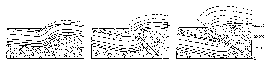
Figure 7. Stages in the Development of a typical Laramide Fold-Thrust Structure in
Southeastern Wyoming (Brown, 1983). A - intial, B - intermediate, C - advanced.
Seven locations were chosen within the project area to demonstrate the applicability of Berg's model.
(1) The hogbacks on either side of the North Fork of Horse Creek, shown on Plate II and Figure 8, are in the initial-intermediate stages of Berg's fold-thrust development. There is a well developed anticlinal fault directly west of and parallel to the hogbacks. The units which form the hogbacks dip steeply eastward and are not overturned. The synclinal fault does not appear to be present.
(2) The hogback to the south of Mill Creek, shown on Plate II, where a limestone quarry was once located, is more advanced than those on either side of the North Fork of Horse Creek but is still in the intermediate stage of development. The anticlinal fault is mapped just west of, and parallel to, the hogback. A synclinal fault emerges from the south side of the hogback, just north of Horse Creek. Units in the footwall are overturned.
(3) The limestone ridges on either side of Fisher Canyon, shown on Plates II and III, are in the late stage of development. The antielinal fault is located to the west of, and parallel to, the limestone ridge. The units which form these ridges are part of imbricate blocks which have been rotated to an overturned position. The synclinal fault, is located parallel to strike within the Chugwater Formation. The Chugwater shows marked loss of stratigraphic thickness in this area and the younger units in the footwall are overturned. It is evident that dip slip along the synclinal fault is small because the Chugwater Formation is present on either side of the fault plane.
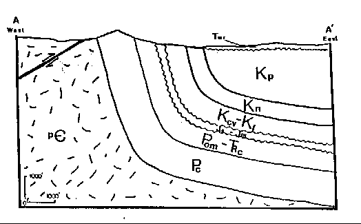
Figure 8. Cross Section A-A', Showing Thrust Fault and Stratigraphy in the vicinity of the North Fork of Horse Creek,
Laramie County, Wyoming. Section trends N.60°E. Its location is shown on Plate II. Geologic symbols are defined on Plate II.
(4) The series of hogbacks south of Fisher Canyon, shown on PLate IV, are in the intermediate stage of development. The anticlinal fault is located west of the hogbacks. The hogbacks themselves are within an imbricate block. The beds of the hogback are nearly vertical at their base and curl to the west near the top of the hogback. This curl represents the crest of the anticline. The synclinal fault is believed to penetrate all the way through the Paleozoic section, however, the rotational distortion of the imbricate block is limited, leaving the block very much intact. The trace of the synclinal fault is located further to the east and is covered by the White River Group.
(5) The tight folds located north of Mesa Mountain, shown on Plate IV, are an anomaly in the pattern described thus far. This area appears to be in a very advanced stage of development. The crustal shortening which was elsewhere taken up almost entirely by thrust faulting, is, here, being accommodated by tight folding as well.
(6) Table and Mesa mountains, shown on PLates IV and V and Figure 9, are also in a very advanced stage of development. The units which crop out as Mesa and Table mountains form a gentle syncline in the hanging wall of the thrust zone. An anticline and its associated anticlinal fault is traced through the Precambrian core located east of the two mountains. The synclinal thrust is located further east where it is covered by the White River Group. The trace of an imbricate of the anticlinal fault is delineated by a line of springs which parallels the mountain front. The imbricate slice is mostly covered by the White River Group, and is expected to be smeared out.
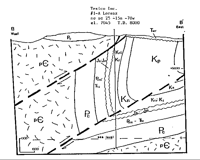
Figure 9. Cross-section B-B', Showing Thrust Faults and Stratigraphy in the vicinity of Table and Mesa Mountains, Laramie
County, Wyoming. Section trends N.60°E..Its location is shown on Plate IV. Geologic symbols are defined on Plate IV.
(7) The hogbacks south of Table Mountain and north of Happy Jack Road, shown on Plate V, are in the intermediate stage of development as were the curled hogbacks south of Fisher Canyon.
Most of the recharge area for the Paleozoic aquifer is hydrologically isolated from the rest of the basin by the thrust faults which delineate the eastern boundary of the Laramie Range. These thrust faults act as impermeable barriers to recharge. Water which reaches these fault planes is forced through joints and fractures in the overlying strata onto the surface. The springs along the trace of the eastern most thrust shown on Plate III, and the water gained by the reach of the North Fork of Horse Creek which flows over the fault located west of the hogbacks in Plate II are a result of these barriers.
The only place in the project area where the recharge area may not be isolated from the rest of the aquifer in the Denver-Julesburg Basin is located north of Horse Creek where the Paleozoic rocks crop out to the west of the anticlinal fault and where there may not be a well developed synclinal fault. It is conceivable for recharge entering the Paleozoic rocks in this area to flow to the basin interior.
Extensional fractures were found along the axis of anticlines located in the series of tight folds north of Mesa and Table Mountains. These fractures do not provide high permeability pathways into the basin interior because they trend north-south.
88-04 Table of Contents
Water Resources Publications List
Water Resources Data System Library |
Water Resources Data System Homepage