| |||||||||||||||||||||||||||||||||||
| |||||||||||||||||||||||||||||||||||
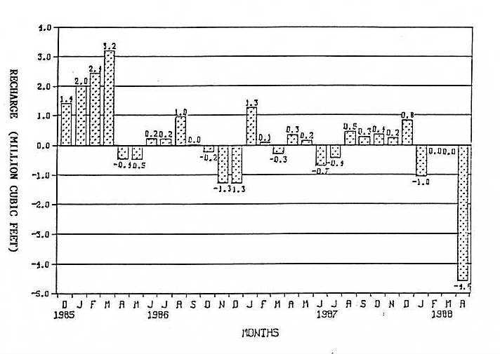
Figure 5. Net Groundwater Recharge for the period December 1985 - April, 1988
Along the North Fork of Horse Creek gauged Reach, Laramie County, Wyoming.
The stream flow losses measured within each of the three subdivisions of the gauged stream reach are shown on Figure 6. The locations of these three subdivisions, called the upper, the middle and the lower segments of the gauged reach, are shown on Figure 3.
The upper segment of the stream shows consistent gains throughout the year. These gains are most likely the result of groundwater flowing from the Laramie Range through open fractures in the Sherman Granite. These fractures are intersected by a west dipping thrust fault in the vicinity of the upper segment of the gauged reach.
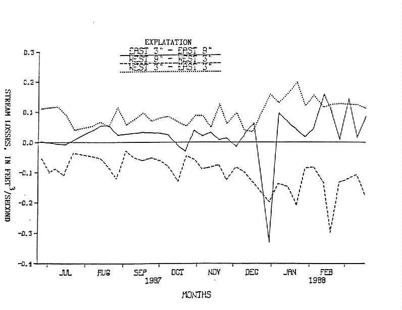
Figure 6. Stream Losses during 1987 and 1988 Along the Subdivisions of the
gauged reach of the North Fork of Horse Creek, Laramie County, Wyoming.
The middle segment of the gauged reach was located in order to isolate the segment of stream which flows over the Casper Formation. The data indicate that this segment of the gauged reach looses water consistently throughout the year. These losses must be either entering fractures in the Casper Formation or evaporating because there is very little alluvium in this part of the canyon. Of these possibilities, I favor loss by evaporation. I observed that negligible quantities of water are recharging through the limestone. Fractures in the Casper Formation which are open enough to transmit appreciable amounts of water are widely spaced and show little evidence of water flowing through them. Where fractures are exposed the walls are rough and angular, indicating that little dissolution has occurred along them. Groundwater staining of the rocks next to the exposed fractures is also limited. In addition, there is not enough water present in them to support much vegetation. Two paleokarst cavities were observed in the area. These are filled with sand and gravel and do not appear to be extensive. Neither the observed fractures nor the paleokarst cavities intersect the gauged reach of the stream.
The most likely explanation for these losses is the wind. The middle segment of the stream flows through a very narrow part of the canyon. Wind blasts through this part of the canyon at terrific speeds. Spray picked up by these gusts was regularly observed which accounts for the unusually high evaporation rates as well as wholesale transport of water droplets. I believe these processes are sufficient to account for the small but consistent losses along this segment of the gauged reach.
The lower segment of the gauged reach shows consistent stream flow losses throughout the year. These losses are best explained as recharge to the alluvium because this segment of the stream flows entirely over alluvial fill which is at least 40 feet thick at the east stream gauging site. Five wells were drilled in the vicinity, four of which were completed in the alluvium. Excellent hydraulic connection between the stream and the alluvium is demonstrated by immediate potentiometric response in the wells to stream flow fluctuations. Potentiometric levels measured in the four alluvial wells reveal flow from the stream to the alluvium consistently throughout the year.
88-04 Table of Contents
Water Resources Publications List
Water Resources Data System Library |
Water Resources Data System Homepage