| |||||||||||||||||||||||||||||||||||
| |||||||||||||||||||||||||||||||||||
The purpose of this thesis is to examine the evidence for groundwater recharge to the Paleozoic aquifer along the east flank of the Laramie Range, Laramie County, Wyoming.
STATEMENT OF THE PROBLEM
The city of Cheyenne, in Laramie County, Wyoming, is anticipating a greater need for water in the near future due to the expansion of F. E. Warren Air Force Base. The Paleozoic aquifer has been identified as a potential water resource in Laramie County by several reconnaissance level studies including Eisen and others (1980), U.S. Forest Service (1981), and Western Water Consultants, Inc. (1982). Little has been done to examine, in detail, the production potential of this aquifer. This thesis attempts to further what is known about the Paleozoic aquifer by examining the evidence for recharge to it.
GEOLOGIC AND GEOGRAPHIC SETTING:
The Denver-Julesburg Basin, shown on Figure 1, is a structural basin which extends south to the Apishapa and Las Animas Arches in Colorado, and north to the Chadron-Cambridge Arch and the Hartville Uplift in Nebraska and Wyoming, respectively. The western perimeter of the basin in Wyoming is delimited by west dipping thrust faults which bound the Laramie Range (Huntoon,1985).
The project area, shown also on Figure 1, is located in the northwest part of the Denver-Julesburg Basin. It includes the western part of Laramie County from R66W to R70W and from T13N to T21N. A smaller area, shown on Figure 2, is defined within the project area for detailed mapping of tectonic structures along the east flank of the Laramie Range.
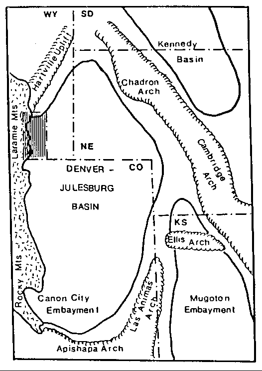
Figure 1. The Denver-Julesburg Basin in Wyoming, Nebraska,
and Colorado. The location of the project area is shaded.
The Paleozoic aquifer is defined in this paper as the saturated and permeable parts of the Casper Formation (Richter, 1984). The Casper Formation crops out within the study area in the foot wall of the thrust faults which bound the Laramie Range and as imbricate slices within the thrust zone. Mesa and Table Mountains, located in the southern part of the mapping area, are the exceptions. The sections of the Casper Formation capping these mountains are not saturated and are part of the hanging wall.
At its deepest in the region the aquifer lies approximately 10,000 feet below the land surface. This deepest part is located along the synclinal axis of the Denver-Julesburg Basin in the vicinity of Cheyenne, Wyoming. In contrast, several perennial and intermittent streams which flow from the Laramie Range cross exposures of the Casper Formation at the western edge of the basin. These streams are a potential source for recharge to the basin aquifers and the focus of this study.
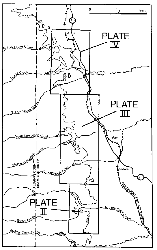
Figure 2. Locations of detailed tectonic maps (Plates
II, III, and IV) Laramie County, Wyoming
PHILOSOPHY OF APPROACH:
Two questions must be addressed when examining evidence for recharge to an aquifer. First, how much water, if any, is entering outcrops of rocks which comprise the aquifer? Second, can water entering the outcrops circulate to the basin interior where production is to occur? Water which enters an outcrop and which is discharged before reaching the basin interior, for example along a fault, does not replace water withdrawn during production and should be excluded from recharge estimates.
A detailed water budget analysis was conducted on the North Fork of Horse Creek to address the first question. The water budget was used to quantify the amount of recharge entering Paleozoic rocks from the North Fork of Horse Creek which is one of several perennial streams in the area which flow across outcrops of the Paleozoic rocks. The amount of recharge to the Paleozoic section along this stream is considered representative of all streams along the east flank of the Laramie Range which cross Paleozoic rocks under similar circumstances, that is, similar tectonic settings.
An understanding of the patterns by which recharge circulates within, between and around the three major components of the groundwater system was obtained through the detailed examination of: 1. the geologic framework through which groundwater flows, and; 2. the shape of the potentiometric surface. The three major components include: the recharge area; the hydraulically interconnected parts of the aquifer; and, the hydraulically isolated compartments within the aquifer.
Examination of the geologic framework involved the identification of tectonic structures which deform the aquifer and an understanding of how these structures influence permeability. For example, an impermeable barrier will exist where motion along a thrust fault has completely juxtaposed aquifer strata against impermeable rocks. Conversely, extensional fractures in the axis of an anticline will act as highly permeable conduits in many environments. Examination of the geological framework also involves the identification of hydraulically isolated compartments within the aquifer. These compartments are sealed off from the rest of the aquifer by impermeable, or semipermeable boundaries which act as barriers around which groundwater must flow.
Further information concerning the patterns by which recharge circulates to the production area is obtained from the shape of the potentiometric surface. The slope of the potentiometric surface is the hydraulic gradient which drives groundwater flow. Circulation patterns are deduced by considering these gradients in conjunction with the permeability distribution.
88-04 Table of Contents
Water Resources Publications List
Water Resources Data System Library |
Water Resources Data System Homepage