| |||||||||||||||||||||||||||||||||||
| |||||||||||||||||||||||||||||||||||
The availability of climatic data is a major consideration in selecting a model for calculating ET. Data input requirements for the different models vary, ranging in complexity from those that use only temperature data to those that require temperature, wind, humidity, and radiation data. Historical records of weather data have been available for the Upper Green River Basin primarily from the National Weather Service's Cooperative Network. The network consists mainly of stations recording maximum and minimum daily temperatures and precipitation. Depending upon the period of interest, approximately 12 of these stations exist in the Basin. In addition, the station at Rock Springs has data on wind, humidity, and solar radiation. Other historical weather data of interest includes records of evaporation rates from pans located at Green River and Farson, although the pan at Farson is no longer in operation. It is apparent that historical weather data for use in ET models are not widely available in the Basin for parameters other than temperature. Thus, one objective of this project was to acquire and analyze additional climatic data.
Weather Stations and Sites
Seven weather stations utilizing CR-21 microloggers manufactured by Campbell Scientific of Logan, Utah for recording weather data were installed in the Green River Basin (Figure 2). The stations were installed during April and May 1983. Sites were selected to provide as even a distribution of area as possible and included Rock Springs, Farson, Merna, Daniel, Big Piney, Seedskadee, and Mountain View. However, the Merna and Daniel sites were selected to provide stations at both the upper and lower portions of Horse Creek which was the area of intensive measurements of mountain meadow ET. Detailed descriptions of each site are given in Appendix A.
The installed weather stations recorded temperature, precipitation, wind, relative humidity, and solar radiation data. The stations' data loggers were programmed to provide values at the following specified time intervals:
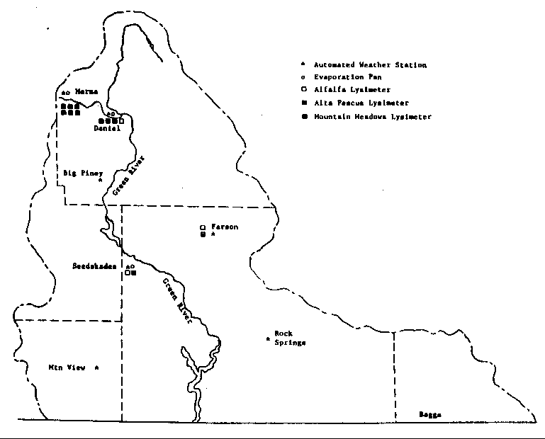
Figure 2. Map of the Green River Basin Showing the Project Sites.
In addition to the automated weather stations, instrumentation at each site included a 4 inch plastic rain gauge. These gauges were monitored weekly and were used as a check on the precipitation recorded by the automated weather stations. Two additional 4-inch plastic rain gauges were operated near the mountain meadow lysimeters along Horse Creek. These were located along the road immediately below the Bridger-Teton National Forest Boundary near lysimeters 3A and 3B and below Merna between lysimeters 3C and 3D. These rain gauges were used to determine the amount of precipitation received by lysimeters 3A through 3F.
Evaporation pans provide one of the simplest, inexpensive, and most widely used methods of estimating evaporative losses and are often used as a reference for ET rates. Thus, three standard class A evaporation pans, with automated reservoirs, were installed and operated during 1984 and 1985. The pans were located adjacent to the weather stations at Merna, Daniel, and Seedskadee. The pans were monitored weekly.
Climatic Data Collection and Reduction
The CR-21 data loggers were programmed to allow a maximum of 15 days between visits. The data stored on the microloggers were transferred to a portable cassette tape through a recorder. The cassette tape was used to transport the data to Laramie where it was transferred to the University of Wyoming Cyber computer system for permanent storage, reduction, and analysis. During the 1985 season the Mountain View station was interrogated via phone.
Monthly summaries of the weather data are given in Tables 1 through 3 while weekly summaries are given in Appendix B. Since all ET measurements were made on a weekly schedule, climatic data for daily and shorter periods are not given in this report but are stored at the University of Wyoming.
Analysis of Climatic Data
Analyses of long-term records were done to compare climatic conditions during 1984 and 1985 with long-term averages and variations (Tables 4 and 5). Data for the long-term averages and variations were derived from the published records of the National Weather Service cooperative network (NOAA, 1965 ... ). The long-term averages used for these comparisons are not the published 30 year normals, which would include the years 1951-1980, but are based on the years 1965-1984.
In general, 1984 is shown to have been a relatively wet summer with the May through October accumulated precipitation at 5 of 6 stations being greater than the long-term average for each station while 1985 was a relatively dry summer with the May through October accumulated precipitation at all 6 of the stations being less than the long-term average for these stations (Table 5). Temperatures for individual months occasionally were considerably less than or greater than the long- term monthly values and are shown in Table 4. However, average temperatures for the entire May through Oct period during 1984 and 1985 were not greatly different than the long-term normal values, except for the 1985 temperature at Seedskadee. The seasonal temperature comparisons are extremely close considering that the sites of the project weather stations and the National Weather Service cooperative stations are not at the exact same locations (Appendix A gives information on specific locations).
TABLE 1. MONTHLY SUMMARY OF CLIMATIC DATA - 1983
===================================================================================================

          	    	  MAX      MIN     MAX     MIN    DEW   SOLAR   TOTAL	WIND	D/N
STATION 	MONTH     TEMP     TEMP    RH      RH     PT    RADTN	PRECIP	RUN	WIND
      			  (F)      (F)     (%)     (%)    (F)   (LY/DY) (IN/MO) (MI/DY) RATIO
---------------------------------------------------------------------------------------------------
                APR       55.	   30.	   98.	   42.	 32.    458.	 .16     178.   1.47
                MAY       60.	   32.	   96.	   34.	 31.2	590.    1.34	 202.   1.50
                JUN       73.	   41.     96.	   28.	 40.1	640.    1.34	 153.	1.71
RCK SPR    	JUL       84.	   46.	   91.	   18.	 39.5	621.     .87	 150.   1.62
                AUG	  88.	   51.	   93.	   17.	 44.9	582.     .59	 136.   1.42
	        SEP	  74.	   40.	   87.	   21.	 33.5   492.	 .35     175.  	1.71

---------------------------------------------------------------------------------------------------
 	        APR	  53.	   26.    100.	   44.	 31.4 	316.	 .75	 176.	1.79
		MAY       59.	   28.	   97.	   35.	 30.7	361.	 .83	 193.   1.86
                JUN	  72.	   38.	   97.	   28.	 40.7	430.	1.10	 154.	1.98
FARSON     	JUL	  80.	   43.	   94.	   18.	 38.9	428.	 .67	 140.	1.75
                AUG 	  84       47.	   94.	   15.	 40.8	456.	2.05	 113.	1.55
                SEP  	  71.      32.	   91.	   18.	 28.9	346.	 .91	 141.  	2.11

---------------------------------------------------------------------------------------------------
     		MAY	  56.	   25.     95.	   33.	-99.0	587.	 .98     -99.	-.99
                JUN       66.  	   34.     99.	   36.	 38.4   538.	 .87	 117.	1.67
MERNA      	JUL	  72.      37.     98.	   36.	 43.3	545.	1.65     105. 	1.51
                AUG	  75.      43.	   99.	   39.	 47.9	455.	2.36	  86.	1.41
                SEP       65.	   31.     97.	   32.	 33.6	400.	1.46	  98. 	1.95

---------------------------------------------------------------------------------------------------
                MAY	  60.	   27.	   99.	   31.	 30.7   593.	 .39	 122.	1.58
                JUN 	  68.	   36.	   99.	   32.	 39.5	553.	 .91	 109.	1.60
DANIEL          JUL	  75.	   39.	  100.     29.	 43.4  	535.	1.14     101.	1.61
                AUG       79.	   43.	  100.	   29.	 47.6  	462.	1.97	  82. 	1.34
                SEP 	  67.  	   29.	   99.	   29.	 34.6   389.	1.69	 104. 	1.70

---------------------------------------------------------------------------------------------------
		MAY	  61.	   26.	  99.	   32.	 30.9	713.    1.22	 127.	1.77
		JUN	  71.	   38.	  99.	   29.	 40.1	700.	 .43	 126.	1.76
B. PINEY	JUL	  78.	   40.	 100.	   23.	 42.4	705.	 .63	 128.	1.70
		AUG	  82.	   47.	 100.	   26.	 48.5	605.	1.85	 103.	1.61
		SEP	  70.	   32.	  95.	   26.	 34.7	493.	1.34	 121.	1.92

---------------------------------------------------------------------------------------------------
		APR	  53.	   28.	  99.	   41.	30.5	424.	1.57 	 168.	1.62
		MAY	  59.	   31.	  96.	   33.	30.2	548.	1.34	 179.	1.64
		JUN	  73.	   41.	  93.	   26.	38.8	572.	1.26	 132.	1.83
SEEDSK.		JUL	  84.	   46.	  87.	   17.	37.8	575.	 .63	 121.	1.68
		AUG	  88.	   52.	  89.	   16.	43.8	521.	 .83	 110.	1.44
		SEP	  73.	   38.	  90.	   21.	33.2	437.	1.57	 150.	1.97

---------------------------------------------------------------------------------------------------
		APR	  52.	   27.	  99.	   53.	32.4	448.     .43     124.	1.38
		MAY	  58.	   30.	  95.	   42.	32.6	584.    1.81	 170.	1.33
		JUN	  69.	   39.	  99.	   41.	43.8	631.	 .98	 151.	1.47
MTN VIEW	JUL	  77.	   43.	  97.	   33.	47.1	600.	 .28	 130.	1.33
		AUG	  81.	   48.	  99.	   37.	53.7	534.	3.39	 107.	1.09
		SEP	  72.	   34.	  95.	   26.	37.2	498.	1.38	 160.	1.57

===================================================================================================
-99.0 INDICATES MISSING DATA


TABLE 2. MONTHLY SUMMARY OF CLIMATIC DATA - 1984
===================================================================================================
			MAX    MIN	MAX	MIN	DEW	SOLAR	TOTAL	WIND	D/N
STATION 	MONTH   TEMP   TEMP	RH	RH	PT	RADTN	PRECIP	RUN	WIND
			(F)    (F)      (%)     (%)     (F)    (LY/DY) (IN/MO) (MI/DY)  RATIO
---------------------------------------------------------------------------------------------------
		APR	50.	24.	93.	42.	24.5	428.	.55	200.	1.36
		MAY	69.	36.	81.	23.	29.3	568.	.43	233.	1.67
		JUN	75.	41.	80.	21.	33.2	573.	.83	172.	1.67
		JUL	86.	50.	83.	17.	40.7	615.	.79	153.	1.57
RCK SPR		AUG	84.	50.	83.	18.	41.1	526.	.94	139.	1.61
		SEP	69.	37.	86.	24.	32.8	451.	1.57	169.	1.55
		OCT	54.	26.	90.	28.	23.3	319.	.24	163.	1.46
		NOV	47.	23.	96.	38.	24.3	214.	.24	203.	1.29

---------------------------------------------------------------------------------------------------
		APR	48.	19.	84.	27.	17.3	421.	.79	177.	1.63
		MAY	68.	28.	77.	15.	19.0	549.	.75	220.	2.16
		JUN	72.	33.	77.	16.	22.8	573.	.94	175.	1.73
		JUL	82.	35.	87.	20.	36.6	605.	3.58	121.	1.66
FARSON		AUG	81.	37.	93.	19.	39.8	530.	.43	108.	1.82
		SEP	68.	28.	94.	20.	28.0	433.	1.34	139.	1.72
		OCT	56.	17.	91.	20.	16.7	321.	.00	115.	1.73
		NOV	42.	11.	96.	39.	16.1	197.	.20	139.	1.56

---------------------------------------------------------------------------------------------------
		APR	45.	16.	91.	44.	19.1	487.	1.30	109.	1.65
		MAY	57.	28.	93.	37.	28.6	548.	1.18	130.	1.97
		JUN	63.	32.	93.	35.	34.8	582.	2.17	116.	1.84
		JUL	74.	41.	92.	35.	44.3	570.	2.99	92.	1.82
MERNA		AUG	72.	40.	96.	39.	45.3	494.	2.44	88.	1.55
		SEP	61.	29.	95.	35.	32.2	400.	2.28	101.	1.66
		OCT	49.	19.	94.	35.	21.8	293.	.63	102.	1.66
		NOV	39.	10.	96.	51.	18.3	164.	.71	99.	1.33

--------------------------------------------------------------------------------------------------

		APR	44.	17.	95.	48.	22.0	494.	.75	136.	1.53
		MAY	59.	27.	96.	35.	30.7	549.	1.14	146.	2.18
		JUN	66.	34.	94.	32.	36.8	599.	.94	143.	1.61
		JUL	77.	42.	95.	30.	45.6	590.	2.09	106.	1.44
DANIEL		AUG	76.	39.	96.	29.	44.1	502.	1.57	104.	1.59
		SEP	63.	26.	96.	29.	31.0	404.	2.09	121.	1.71
		OCT	50.	19.	95.	31.	21.7	305.	.28	126.	1.46
		NOV	39.	11.	96.	48.	18.2	200.	.31	112.	1.49

--------------------------------------------------------------------------------------------------
		APR	47.	19.	95.	43.	23.0	452.	.83	134.	1.81
		MAY	64.	28.	93.	27.	29.5	546.	.83	158.	2.09
		JUN	71.	34.	93.	24.	34.5	570.	.94	137.	1.77
		JUL	83.	44.	94.	21.	42.9	563.	1.69	115.	1.65
B. PINEY	AUG	81.	42.	95.	22.	43.1	476.	.28	105.	1.66
		SEP	67.	28.	96.	25.	31.5	403.	2.09	117.	1.66
		OCT	53.	17.	94.	24.	19.9	304.	.04	102.	1.83
		NOV	42.	12.	96.	46.	18.7	197.	.39	96.	1.51

--------------------------------------------------------------------------------------------------
		APR	49.	24.	91.	44.	23.3	443.	.83	168.	1.57
		MAY	66.	30.	86.	28.	29.4	573.	.55	208.	2.01
		JUN	75.	35.	84.	22.	33.0	576.	.75	167.	1.75
		JUL	85.	48.	87.	22.	43.8	592.	2.13	125.	1.70
SEEDSK.		AUG	84.	48.	86.	22.	42.6	506.	.63	121.	1.67
		SEP	69.	36.	89.	26.	34.1	427.	1.85	136.	1.84
		OCT	55.	24.	90.	27.	22.7	310.	.08	133.	1.61
		NOV	43.	19.	94.	56.	23.3	211.	.43	171.	1.33

--------------------------------------------------------------------------------------------------
		APR	48.	21.	92.	48.	24.5	456.	.63	191.	1.22
		MAY	64.	32.	88.	33.	33.1	568.	.55	224.	1.76
		JUN	69.	37.	93.	30.	38.9	577.	.67	174.	1.33
		JUL	80.	46.	90.	29.	46.5	561.	1.34	127.	1.22
MTN VIEW 	AUG	78.	46.	89.	30.	46.6	471.	1.02	123.	1.10
		SEP	68.	34.	90.	30.	35.0	427.	1.50	157.	1.29
		OCT	52.	25.	91.	33.	25.2	321.	.28	158.	1.16
		NOV	45.	17.	92.	47.	22.4	208.	.24	165.	1.38

=================================================================================================


TABLE 3. MONTHLY SUMMARY OF CLIMATIC DATA - 1985
================================================================================================
			MAX    MIN	MAX	MIN	DEW	SOLAR	TOTAL	WIND	D/N
STATION 	MONTH   TEMP   TEMP	RH	RH	PT	RADTN	PRECIP	RUN	WIND
			(F)    (F)      (%)     (%)    (F)     (LY/DY) (IN/MO) (MI/DY)  RATIO
-----------------------------------------------------------------------------------------------

		APR	60.	28.	80.	20.	18.9	546.	.12	196.	1.74
		MAY	72.	36.	78.	15.	24.2	615.	.43	164.	1.74
		JUN	81.	45.	56.	16.	24.0	687.	.63	170.	1.60
RCK SPR		JUL	89.	52.	73.	11.	34.3	617.	.39	131.	1.78
		AUG	85.	45.	43.	11.	20.0	628.	.04	115.	1.81
		SEP	68.	35.	82.	18.	24.3	439.	.91	139.	1.26
		OCT	59.	27.	86.	25.	21.0	355.	.47	148.	1.76

-----------------------------------------------------------------------------------------------
		APR	61.	20.	90.	18.	17.3	534.	.16	175.	2.02
		MAY	70.	27.	96.	17.	25.3	605.	.91	174.	1.79
		JUN	77.	34.	85.	18.	27.8	646.	1.77	163.	1.91
FARSON		JUL	86.	40.	93.	12.	36.2	574.	.39	119.	1.67
		AUG	82.	37.	75.	11.	22.7	607.	.08	163.	2.16
		SEP	66.	25.	95.	18.	23.2	446.	1.26	162.	1.97
		OCT	58.	18.	92.	21.	16.4	342.	.43	151.	1.65

-----------------------------------------------------------------------------------------------
		APR	53.	21.	92.	23.	17.1	565.	.16	116.	1.73
		MAY	60.	27.	91.	25.	25.5	541.	.67	121.	1.77
		JUN	68.	33.	90.	23.	30.5	640.	.83	117.	1.76
MERNA		JUL	77.	41.	87.	22.	38.7	591.	1.97	100.	1.57
		AUG	72.	34.	80.	17.	27.3	582.	.12	115.	1.72
		SEP	58.	25.	93.	28.	26.0	389.	2.44	110.	1.91
		OCT	51.	20.	90.	28.	19.8	333.	.79	109.	1.67

----------------------------------------------------------------------------------------------
		APR	56.	20.	96.	22.	20.0	530.	.20	147.	1.94
		MAY	64.	26.	95.	23.	27.8	534.	.67	142.	1.87
		JUN	69.	34.	92.	29.	37.3	622.	.94	138.	1.74
DANIEL		JUL	79.	43.	97.	33.	47.4	583.	1.57	110.	1.45
		AUG	76.	31.	97.	20.	33.5	564.	.16	131.	1.78
		SEP	60.	25.	98.	31.	29.6	398.	2.09	134.	2.06
		OCT	54.	17.	97.	30.	21.9	321.	.28	130.	1.65

----------------------------------------------------------------------------------------------
		APR	59.	21.	95.	18.	18.6	536.	.00	131.	2.19
		MAY	67.	28.	95.	20.	26.5	560.	.67	134.	2.11
		JUN	77.	36.	90.	17.	30.3	625.	.55	126.	2.06
B. PINEY	JUL	86.	44.	97.	13.	39.1	566.	.98	96.	1.78
		AUG	81.	34.	86.	12.	26.1	583.	.04	124.	2.18
		SEP	63.	27.	98.	22.	27.4	419.	1.50	126.	2.36
		OCT	57.	18.	97.	21.	19.3	329.	.12	110.	2.04

-----------------------------------------------------------------------------------------------
		APR	61.	25.	76.	17.	16.6	540.	.04	188.	1.92
		MAY	71.	36.	78.	16.	24.2	591.	.83	176.	1.64
		JUN	80.	43.	63.	14.	25.8	650.	.59	161.	1.87
SEEDSK.	 	JUL	89.	52.	67.	11.	33.0	590.	.55	132.	1.57
		AUG	84.	44.	49.	11.	21.1	608.	.12	168.	2.05
		SEP	67.	34.	82.	18.	24.4	433.	.98	161.	1.77
		OCT	60.	24.	82.	19.	17.0	345.	.08	160.	1.48

----------------------------------------------------------------------------------------------
		APR	54.	24.	89.	28.	21.6	484.	.31	193.	1.68
		MAY	69.	32.	92.	17.	29.2	642.	.00	178.	1.50
		JUN	75.	38.	90.	20.	33.8	652.	1.38	154.	1.36
MTN VIEW	JUL	82.	48.	88.	21.	43.4	566.	1.57	125.	1.13
		AUG	79.	40.	76.	12.	27.2	612.	.05	171.	1.44
		SEP	66.	29.	90.	21.	27.6	432.	.59	160.	1.48
		OCT	58.	24.	89.	26.	22.7	342.	.98	158.	1.29
===============================================================================================


TABLE 4. LONG-TERM NORMAL VS MEAN 1984 AND 1985 TEMPERATURES*
=============================================================================================
			                                                     AVERAGE
STATION 	YEAR     APR     MAY   JUNE     JULY    AUG     SEPT   OCT   MAY-OCT
---------------------------------------------------------------------------------------------

		1985	44.0	54.0	63.0	70.5	65.0	51.5	43.0	57.8
RCK SPR		1984	37.0	52.5	58.0	68.0	67.0	53.0	40.0	56.4
		NORMAL	39.9	50.1	59.7	67.9	65.6	55.5	43.6	57.1
		S. DEV.	3.28	2.70	3.05	1.23	2.69	3.40	3.58

--------------------------------------------------------------------------------------------
		1985	40.5	48.5	55.5	63.0	59.5	45.5	38.0	51.7
FARSON		1984	33.5	48.0	52.5	58.5	59.0	48.0	36.5	50.4
		NORMAL	36.9	47.0	56.0	63.2	61.0	51.0	39.4	52.9
		S. DEV.	3.36	2.35	2.69	1.65	2.21	2.95	3.60

-------------------------------------------------------------------------------------------
		1985	37.0	43.5	50.5	59.0	53.0	41.5	35.5	47.2
MERNA		1984	30.5	42.5	47.5	57.5	56.0	45.0	34.0	47.1
		NORMAL	30.1	41.1	49.1	56.2	55.1	46.9	37.1	47.6
		S. DEV.	3.39	2.14	2.10	1.28	2.24	2.98	3.21

--------------------------------------------------------------------------------------------

		1985	38.0	45.0	51.5	61.0	53.5	42.5	35.5	48.2
DANIEL		1984	30.5	43.0	50.0	59.5	57.5	44.5	34.5	48.2

--------------------------------------------------------------------------------------------
		1985	40.0	47.5	56.5	65.0	57.5	45.0	37.5	51.5
B. PINEY	1984	33.0	46.0	52.5	63.5	61.5	47.5	35.0	51.0
		NORMAL	33.8	44.7	53.7	60.1	57.0	47.3	37.0	50.0
		S. DEV.	2.80	2.39	2.49	1.23	1.96	2.97	3.02

-------------------------------------------------------------------------------------------
		1985	43.0	53.5	61.5	70.5	64.0	50.5	42.0	57.0
SEEDSK.		1984	36.5	48.0	55.0	66.5	66.0	52.5	39.5	54.6
		NORMAL	37.5	47.3	56.8	64.4	62.7	51.9	40.0	53.9
		S. DEV.	3.06	2.44	2.34	1.54	2.60	2.66	3.04

-------------------------------------------------------------------------------------------
		1985	39.0	50.5	56.5	65.0	59.5	47.5	41.0	53.3
MTN VIEW	1984	34.5	48.0	53.0	63.0	62.0	51.0	38.5	52.6
		NORMAL	37.5	47.9	56.1	63.2	61.8	53.5	42.6	54.2
		S. DEV.	3.57	2.27	2.42	1.15	2.28	2.55	3.57

==========================================================================================
ALL TEMPERATURES ARE IN DEGREES F. NORMAL INCLUDES YEARS 1965 - 1984


TABLE 5. LONG-TERM NORMAL VS 1984 AND 1985 ACCUMULATED PRECIPITATION*
============================================================================
STATION		 YEAR    MAY     JUNE    JULY    AUG     SEPT    OCT
----------------------------------------------------------------------------

		1985	0.43	1.24**	1.63	1.67	2.58	3.05
RCK SPR		1984	0.43	1.26	2.05	2.99	4.56	4.90**
		NORMAL	1.31	2.28	3.33	4.06	4.95	5.78

--------------------------------------------------------------------------
		1985	0.91	2.68	3.07	3.15	4.41	4.84
FARSON		1984	0.75	1.69	5.27	5.70	7.04	7.04**
		NORMAL	1.24	2.40	3.37	4.18	4.94	5.80

--------------------------------------------------------------------------
		1985	0.67	1.50	3.47	3.59	6.03	6.82
MERNA		1984	1.18	3.35	6.34	8.78	11.06	11.95**
		NORMAL	1.25	2.85	4.19	5.55	6.94	8.05

--------------------------------------------------------------------------
		1985	0.67	1.61	3.18	3.34	5.43	5.71
DANIEL		1984	1.14	2.08	4.17	5.74	7.83	9.35**

-------------------------------------------------------------------------
		1985	0.67	1.22	2.20	2.24	3.74	3.86
B. PINEY	1984	0.83	1.77	3.46	3.74	5.83	5.89**
		NORMAL	0.99	2.19	3.05	3.98	5.07	5.59

-------------------------------------------------------------------------
		1985	0.83	1.42	1.97	2.09	3.07	3.15
SEEDSK.		1984	0.55	1.30	3.43	4.06	5.91	6.02**
		NORMAL	0.96	2.06	2.85	3.50	4.51	5.12

------------------------------------------------------------------------
		1985	1.38	2.95	3.00	3.59	4.57
MTN VIEW	1984	0.67	2.01	3.03	4.53	5.07**
		NORMAL	1.14	2.05	2.95	3.95	4.86

========================================================================
* ALL PRECIPITATION IS IN INCHES.  NORMAL INCLUDES YEARS 1965 - 1984
** DATA EXTRAPOLATED TO INCLUDE ENTIRE MONTH
In general, irrigation requirements of agricultural crops might be expected to be greater during hot dry years as compared to average years. Low precipitation leads not only to greater irrigation applications but tends to cause lower humidity conditions which usually increase water use rates. Increased consumptive use rates also are usually associated with higher temperatures. Thus, 1984 might be expected to be a year of lower than normal irrigation requirements while 1985 would be expected to be a year of greater than normal irrigation requirements.
87-06 Table of Contents
Water Resources Publications List
Water Resources Data System Library |
Water Resources Data System Homepage