| |||||||||||||||||||||||||||||||||||
| |||||||||||||||||||||||||||||||||||
ASSESSMENT OF A FLOW ENHANCEMENT PROJECT
AS A RIPARIAN AND FISHERY HABITAT
MITIGATION EFFORT
S.W. Wolff
T.A. Wesche
W.A. Hubert
1986
Symposium Proceedings WWRC-86-20
In
Proceedings of the Twenty-First
Annual Meeting of the Colorado-Wyoming
Chapter of the American Fisheries Society
S.W. Wolff
Department of Zoology and Physiology
Wyoming Water Research Center
University of Wyoming
Laramie, Wyoming
T.A. Wesche
Wyoming Water Research Center
University of Wyoming
Laramie, Wyoming
W.A. Hubert
Wyoming Cooperative Fishery & Wildlife Research Unit
University of Wyoming
Laramie, Wyoming
ASSESSMENT OF A FLOW ENHANCEMENT PROJECT AS A
RIPARIAN AND FISHERY HABITAT MITIGATION EFFORT
Steven W. Wolff and Thomas A. Wesche
Wyoming Water Research Center
Laramie, Wyoming 82071
Wayne A. Hubert
Wyoming Cooperative Fish and Wildlife Research Unit
University of Wyoming, Laramie, Wyoming 82071
ABSTRACT
As part of mitigation procedures for impacts of the Cheyenne Stage II water development project in the Little Snake River drainage, Wyoming, the flow in a previously ephemeral watercourse on the east slope of the Laramie Range is being enhanced to create a perennial stream. Water used to enhance this flow is obtained by transbasin diversion. The mitigation is being done in hopes of enhancing the riparian and fishery habitat. Currently, a comprehensive study is being conducted at the University of Wyoming to assess the results of this action and the feasibility of this strategy for application to other watersheds. The project focuses upon defining conveyance efficiency, channel development, groundwater storage, alteration of riparian vegetation, and creation of fish habitat. In this paper we describe the overall mitigation project, our study design, and preliminary results.INTRODUCTION
With the ever-increasing demand for water in the western United States, more efficient utilization of existing supplies is needed. A goal of water development projects should be to maximize benefits to the greatest number of water users. These water users generally fall into four main categories: (1) industry, (2) municipalities, (3) agriculture, and (4) recreation. A common method for a municipality to obtain water for its use is by transbasin diversion. Such projects can have dramatic affects on the areas below the point of diversion by reducing or eliminating streamflow, resulting in a serious impact to the riparian and aquatic resources.Diverted water supplies are usually conveyed by means of either pipelines or open channels. An alternative method for conveyance is by controlled releases of diverted water into ephemeral channels, thereby creating perennial streams and increasing the amount of riparian and aquatic habitat in the area. To date, such a strategy has received little attention. Currently, the City of Cheyenne, Wyoming is being required by the U.S. Forest Service to pursue such a conveyance strategy as one mitigation measure for its water development program.
During the early 1960's, the City constructed a transbasin diversion and conveyance system for bringing water from the Douglas Creek drainage of the Snowy Range 90 miles west of Cheyenne. Water stored in Rob Roy Reservoir on Douglas Creek was conveyed by pipeline approximately 60 miles across the Laramie plains to the Sherman Mountains west of Cheyenne. Here, the water was stored in Granite Springs and Crystal Lake Reservoirs and released to the City as needed via Crow Creek. As the City's water rights, however, were in the upper Little Snake drainage of the Colorado River basin of south-central Wyoming, a repayment system had to' be built to bring the Little Snake water into the North Platte River basin. This entailed the construction of diversion facilities on the West Slope of the Sierra Madre Mountains, a conveyance tunnel through the Continental Divide, and a storage reservoir on Hog Park Creek on the East Slope. Water stored in Hog Park Reservoir was then released as repayment to the North Platte River via Hog Park Creek and the Encampment River. Termed Stage I, this system currently provides the City with 7,400 acre-feet per year.
Because of increasing development in Wyoming, the City of Cheyenne foresaw the need for additional municipal water supplies. In response to this need, construction began on the Stage II development program during 1982-83. This enlargement and expansion of the Stage I collection, diversion, and conveyance system will provide the City with approximately 23,200 acre-feet per year. It is because of impacts from Stage II that the City is expected to mitigate by controlled year-round releases of water into a previously ephemeral watercourse. South Fork of Middle Crow Creek (SFMCC) and one of its tributaries were selected for this release.
The goal of our study is to assess the results of the mitigative action and the feasibility of this strategy for application to other watersheds. Specific objectives include defining conveyance efficiency, channel development, groundwater storage, alteration of riparian vegetation and creation of fish habitat.
DESCRIPTION OF STUDY AREA
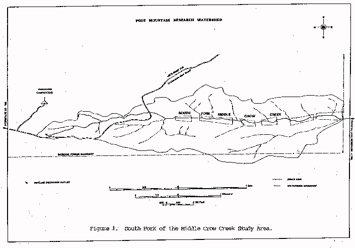
The SFMCC is located within the Platte River basin of southeast Wyoming, approximately 20 miles east of Laramie. The headwaters of this ephemeral stream rise on the east slope of the Sherman Mountains at an elevation of approximately 8,200 feet above mean sea level within the boundaries of Medicine Bow National Forest. From its headwaters, the drainage runs in an easterly direction for approximately 10 miles to its confluence with the Middle Fork of Crow Creek between Granite Springs and Crystal Lake Reservoirs. At the forest boundary, 5.5 channel miles below the headwater, the contributing watershed encompasses approximately 3.2 square miles (Figure 1). Historically, the SFMCC within the National Forest boundary has been an ephemeral stream which flows primarily in response to spring snowmelt runoff and intense precipitation events. Scattered springs and seeps throughout the drainage provide limited areas of surface flow during non-runoff periods. Active channel development in the system is restricted to several reaches where headcutting occurs and-to areas in the vicinity of beaver activity. The upper 40 percent of the study area is characterized as a steep, narrow, wooded, geologically-controlled valley with occasional low-gradient sections with channel development controlled by beaver and debris damming. Outcrops of Sherman granite are common. The lower 60 percent of the study area consists primarily of a lower-gradient, wider valley with thicker alluvial soils and vegetation predominated bygrasses and forbs. These meadow habitats to a large degree most likely result from .previous beaver activity. Historic land uses of the Pole Mountain area include cattle grazing, wildlife habitat, watershed, ,and recreation (fishing, hunting, camping, hiking and rock climbing). Given its location between two of Wyoming's largest cities, Laramie and Cheyenne, recreational use of the area is heavy.
Click Image to Enlarge
METHODS
During 1984, a study was initiated to assess the objectives previously described. To determine the hydrologic and geomorphic response of the watershed, 47 cross-sections were selected, permanently marked, and surveyed across the valley floor on the SFMCC and its tributary from the headwaters to the Medicine Bow National Forest boundary to allow assessment of the rate of channel development in response to flow augmentation. Cross-sections were located based primarily upon channel gradient, vegetative type, and the type of channel control exhibited (geologic, vegetative or biologic). During 1985, four alluvial groundwater wells cased with two-inch PVC were drilled along each of the cross-sections (a total of 183 wells) to evaluate change in shallow groundwater storage. In coordination with the groundwater network, four Parshall flumes (two-foot throat width) were installed and equipped with water stage recorders to measure the change in surface flow throughout the study area over time. Also, two recording precipitation gages with Alter Shields were established within the watershed to assess precipitation-runoff relationships. Evaluation of the riparian resource has been divided into three main phases. The first phase, begun in 1985, is to follow changes in the amount and type of riparian vegetation due to the flow augmentation. The second phase, also begun in 1985, is directed at the assessment of the affect of beaver activity on riparian zones. The final phase. Phase III, has not begun but is closely associated with Phase 1. Phase III is the evaluation of the effect livestock grazing may have on developing riparian zones.Baseline aquatic habitat data were collected during 1985 on the SFMCC as part of the WWRC study. Eleven stream sites were sampled by establishing three permanent cross-sections at each site. Channel width, cross-sectional area, water depth, water velocity, substrate and cover were measured along each cross-section. Four additional stream sites were selected for more intensive baseline habitat analysis using the U.S. Fish and Wildlife Service Physical Habitat Simulation (PHABSIM) system. Habitat surveys were also made on 14 beaver ponds throughout the study reach with volumetric maps made of each pond to determine baseline dam height, surface area, mean depth, and maximum depth.
Currently, no fish are known to exist within the study area. During 1986, additional stream habitat sites will be established in both the North Fork of the Little Snake drainage and the Douglas Creek drainage. This is being done to enable an assessment of the trade-offs involved between habitat losses on both North Fork Little Snake and Douglas Creek drainages, compared to habitat gains on SFMCC. All stream habitat sites on each of the three watersheds, along with all beaver ponds on SFMCC, will be sampled annually through 1988, and possibly longer.
Also, attempts are currently being made to add an economic evaluation to the project.
DISCUSSION
Little is known regarding the potential for success of this mitigative action. Thus, the overall objective of this research project will be to determine the hydrologic and biologic feasibility of transporting municipal water via ephemeral channels. Based upon these analyses, predictive models will be developed for estimating the relative success of the mitigation in future years as well as for other management situations. Results from this project should be of interest to any agency or group involved with water development and the environmental ramification of such development.Funding for this research is presently being provided by the Wyoming Water Research Center, the Wyoming Game and Fish Department and the University of Wyoming, with cooperation from the Medicine Bow National Forest. Principal investigators on the project, and their respective departments, include: Thomas A. Wesche, Wyoming Water Research Center; Wayne A. Hubert, Wyoming Cooperative Fish and Wildlife Research Unit; Quentin D. Skinner, Department of Range Management; and Victor R. Hasfurther, Department of Civil Engineering/Wyoming Water Research Center.
Water Resources Publications List
Water Resources Data System Library |
Water Resources Data System Homepage