| |||||||||||||||||||||||||||||||||||
| |||||||||||||||||||||||||||||||||||
CONVEYANCE LOSSES DUE TO
RESERVOIR RELEASES
Randy A. Pahl
Victor R. Hasfurther
July 1985
Proceedings Paper WWRC-85-25
In
Development and Management Aspects of
Irrigation and Drainage Systems
Proceedings Spec. Conf.
Irrigation Drainage Division, ASCE
San Antonio, Texas
July 17-19, 1985
Randy Pahl
Graduate Student
Victor R. Hasfurther
Professor
Civil Engineering Department
Associate Director
Wyoming Water Research Center
University of Wyoming
Laramie, Wyoming
CONVEYANCE LOSSES DUE TO RESERVOIR RELEASES
Randy A. Pahl, A.M. ASCE, and Victor R. Hasfurther*, M.ASCE
ABSTRACT: Three natural streams in Wyoming were studied in order to estimate incremental conveyance losses associated with incremental increases In stream flow. For each study area, all surface water inflow and outflow was measured before, during, and following a significant reservoir release. With this data, conveyance losses were determined for the control period using a water budget analysis. The major losses were attributed to bank storage and a decrease in ground water inflow. The conveyance loss results for the three study areas ranged from 0.34 to 1.66 percent per mile.INTRODUCTION
The recent growth in the areas of energy development and, to a lesser extent, agriculture and municipalities has increased pressure on available water resources throughout the U.S., and especially the Western U.S. with its prior appropriation doctrine (first in right, first in use). In order to satisfy these increased needs, it has become necessary to develop unappropriated water or to transfer water already appropriated for other uses in the West. Energy development companies and municipalities have found it necessary to purchase agricultural water rights and then petition for a change in use, a change in place of use, and a change in the point of diversion of these water rights. Wyoming water law allows these changes to occur, provided the Board of Control feels that certain conditions stated in the State statutes are met. The Wyoming State Statutes, Section 41-3- 104(a) (6) declare:
In order to protect downstream prior appropriators when water is transferred to a point downstream, conveyance losses need to be assigned to the transported water. However, there is a scarce amount of technical data available to aid the responsible state government body in determining values of conveyance losses that would be equitable to all parties concerned. Many decisions in the past have been based on the best estimates of the people managing the stream in question. This is not unrealistic, but better quantification of conveyance losses would be more desirable.
FACTORS AFFECTING CONVEYANCE LOSSES
When discussing conveyance losses in a stream. It is first necessary to define the term "losses." There are losses associated with the total flow in the stream that will exist year round. There are also losses associated with an incremental increase in the natural flow that will only exist when the increase exists. This increase may be the result of a reservoir release or a change in the point of diversion of an existing water right. In a case involving an incremental increase in flow due to a water transfer or reservoir release, the problem arises as to which "losses" the water user should be responsible. There are those who feel that a percentage of the total losses should be assigned to the increase, while others feel that the incremental losses caused by the increases should be used. The amount of the increase in relation to the natural flow will partly determine which loss is the greatest. The incremental loss approach was taken in this paper due to the difficulties involved in determining total losses.
A large number of factors (>15) affecting conveyance losses complicates the determination of the losses. M. C. Hinderlider, former Colorado State Engineer, discussed the difficulties involved in determining conveyance losses. Hinderlider states: "These factors alone, through hundreds of different combinations and changes daily imposed by the elements of nature, may produce a million different results having a direct bearing on this complicated problem....All of these factors are seriously affected from time to time by periodic changes in the hydrologic cycle, and in the normalcy of the rate and amount of precipitation, which have profound effects upon the underground water table of a drainage basin, and the rate and amount of return flow tributary to any natural water course." (4)
In an effort to simplify its quantification, Colorado's administrators and engineers have split the conveyance losses that are chargeable to reservoir releases into four major components: evapotranspiration, inadvertent diversions, channel storage, and bank storage (1,2,3,4,6). In addition to these components, this paper includes a fifth component of loss due to a decrease in groundwater inflow. These five components, to a large degree, include the effects of the many factors important to incremental losses in a perennial stream. Changes in any one of these five major components can influence the amount of the incremental conveyance losses. A large number of studies have been performed in an attempt to define the extent to which some of these components influence the hydrologic cycle of the stream and concurrently influence losses.
These studies on incremental conveyance losses in stream systems have resulted in loss estimates from 0.35 percent per mile to essentially zero for small incremental amounts of flow on large stream volumes on perennial streams (1,2,3,4,6). It was found that ephemeral type streams could produce much higher losses, 11.5 percent per mile (5), on the average, compared to perennial streams.
In Wyoming, very little information and essentially no detailed field studies on conveyance losses had been made in the past. In the future. It is expected that more transfers of water from upstream locations, either through building of reservoirs or transfer of water rights, will occur to downstream locations because of increased development. Since the mode of transportation will most likely be the natural stream channel, a study on incremental conveyance losses was undertaken, and the results are presented in this paper.
STUDY AREAS
The initial studies were to test a method of analysis on reservoir releases to be conveyed to downstream owners of the reservoir storage. Three study sites were selected on perennial streams. These study sites were:
METHODOLOGY
At each study site, a network of stream gages was established at all locations of surface water flow into and out of the main stream system. Some flows were not monitored since they remained fairly constant during the study periods and were generally small. Continuous stage recorders were installed at all flow measurement locations, and stage-discharge rating curves were developed.
With the recorders installed, the system was then monitored for a period of time to insure that the surface flows in and out of the system were relatively stable; i.e., gains into the creek from ground water, irrigation return flows, and ungaged surface flows were constant. Once a stable condition was maintained, additional water was released from reservoir storage to provide an incremental increase in flow. This increased flow was then maintained for a period of several days, after which time the flow was reduced to approximately the same rate that existed prior to the reservoir release.
The hydrologic budget approach was used in the analysis of the collected streamflow data. This method required a comparison of the quantities of inflow and outflow in order to determine conveyance losses. In general terms, the water budget relationship can be written as
                                0 = I - D + G                      (1)

where 0 Is the surface flow out of the system,
      I Is the surface flow into the system,
      D is the surface flow diverted out of the system,
  and G is the gain or loss in the flow in the entire system.
In the above equation, the 'G' term is a lumped variable which contains the effects of ground water flow and all sources of loss, such as surface evaporation, evapotranspiration, etc., and can be either positive or negative in sign. All of the rivers discussed in this paper were gaining at the time of the data collection, so the `G' term was considered to be positive in the analyses. However, if a stream is losing, the approach discussed here is still applicable.
Incremental losses in the system due to the reservoir release are defined by this approach as the decrease in the gains or the increase in the losses during an increase of surface flow. The incremental loss can be calculated by manipulation of Eq. (1).
                             L = [DI - DD] - DO                    (2)

where  L is the incremental loss due to the release,
      DI is the Increase in the surface inflow due to the release,
      DD is the increase in diversions during the release, and
      DO is the increase in the surface outflow due to the release.
All of the components of Eq. (2) are  in the same units (i.e., c.f.s.
or acre-feet).
Eq. (2) provides a simple means for determining the losses associated with a reservoir release based solely on surface flow records. With this relationship, losses can be computed either in terms of the flow rate or the volume of the reservoir release by solving Eq. (2) in units of c.f.s. or acre-feet, respectively. Some adjustments may have to be made to account for travel times. Certain limitations exist on the use of Eq. (2).
In the first place, all sources of loss are lumped together into one value. Included in this value are losses due to bank storage, channel storage, a reduction in the ground water contribution, and an increase in surface evaporation and evapotranspiration. Determination of each of these separate losses would require more field data than was collected in this study.
Secondly, use of Eq. (2) is limited to time periods when meteorological conditions are fairly consistent. Precipitation and its effect upon the surface and subsurface flows are not accounted for in this relationship. In most of the cases studied, there was negligible rainfall during the study periods; so this was not a problem.
Perhaps the most important limitation on the use of Eq. (2) pertains to the stability of the study area. Since this relationship determines the change in gains during a reservoir release, it is necessary that the flow regime in the study area is in a stable condition with relatively constant gains. This will insure that the calculated decrease in gains is mainly due to the introduction of additional water into the stream. Any large changes in activities, such as irrigation, during the study period could affect the amount of return flows which, in turn, could affect the gains measured before, during, and after the reservoir release.
The rating curve for each gage within the system was used to develop hydrographs which formed the basis for the determination of the conveyance loss. It became apparent from the measured losses that they were small enough to be affected by the degree of accuracy of the established rating curves. As a result, 95 percent confidence limits were placed on rating curves in an attempt to better quantify the accuracy of the conveyance losses.
RESULTS
The analysis of results will be shown only for the Piney Creek study area, but all three study area results will be summarized at the end of this discussion.
Fig. 1 indicated the results of one of the two reservoir releases on Piney Creek. The hydrographs shown have not been adjusted for travel time. In order to make this data more understandable, the diversion hydrograph was first adjusted for travel time and was then subtracted from the inflow hydrograph, with the results indicated on Fig. 2. This plot is easier to read, and it clearly shows the relatively constant gains that existed in the system prior to the reservoir release. As discussed earlier, a stable system with constant gains is one of the prerequisites for the analysis technique used.
With the stability of the system confirmed, Eq. (2) was utilized to estimate the conveyance loss associated with the release. Changes in the diversions during the release were significant; however, the amount was not an inadvertent diversion and, thus, the increase in the diversion term was not included as part of the conveyance loss value. The DI and the DO terms were defined as that amount of additional flow in and out of the system, respectively, due to the reservoir release. To determine quantities for these terms, it was first necessary to estimate the base flows that would have existed had there been no release. This was accomplished using the most simple base flow separation technique which results in a straight line, on the hydrograph, connecting the flow prior to the release to the flow following the release (Fig. 1). The flow above these lines was then used to determine values for DI, DO, and DD. Losses were determined in terms of flow rate and volume.
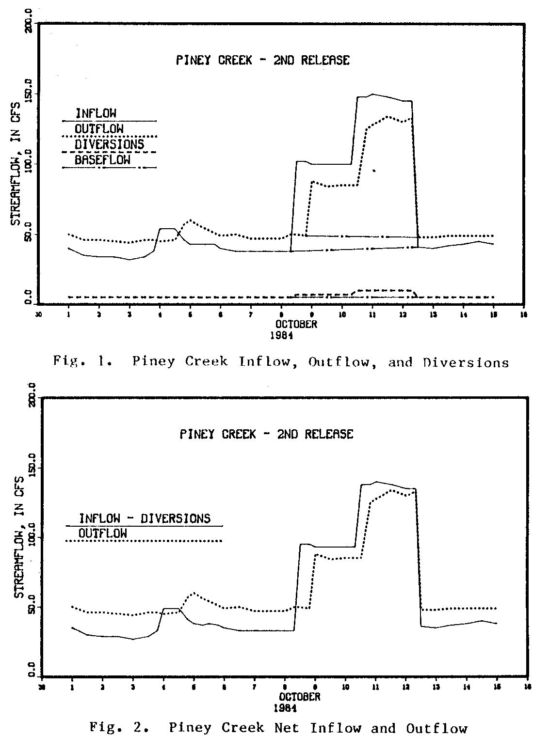
Using this approach, the increase in the inflow was calculated to be an average of 84.6 c.f.s. for a period of 4 days, or a total volume of 670 acre-feet, while the average increase in the outflow was calculated to be 56.3 c.f.s. for a period of 3.66 days, or a total volume of 408 acre-feet. The average increase in the diversions was estimated to be 3.7 c.f.s. for a period of 4 days, or a total volume of 30 acre-feet.
With these values, the average conveyance loss was calculated to be 24.6 c.f.s. or 232 acre-feet. These loss figures were then converted to a percentage of the net inflow; i.e., the inflow minus the diversions. Due to the difference in the time bases of the inflow and outflow hydrographs, the volumetric loss was larger than the loss based upon the flow rate, with values of 1.66 percent per mile volumentric) and 1.39 percent per mile (flow rate). Using volumetric values, the conveyance loss calculations were repeated with the 95 percent confidence limits placed on the hydrographs. Use of these limits resulted in a range of possible conveyance losses from 1.31 percent to 1.99 percent per mile of river. The results of these calculations are summarized in Table I, along with all the other analyses made on all study areas.
                                TABLE I
                   Summary of Conveyance Loss Results
  _____________________________________________________________________
                  Average     Average            Upper 95%    Lower 95%
                  Increase    Increase   Loss   Confidence   Confidence
                  of Inflow,  in Stage,  % per   Limit, %     Limit, %
Study Area          c.f.s.      feet     mile    per mile     per mile

Piney Creek, 1st      41.8      0.18     0.76      1.49        0.00
Piney Creek, 2nd      84.6      0.47     1.66      1.99        1.31
Laramie River
   Lower Reach       114.6      1.02     0.34      1.03          *
   Upper Reach        91.3      0.35       *         *           *
New Fork River       203.3      1.26     0.85      3.27          *
  *Results showed an increase in gains
The release shown for Piney Creek indicates that the majority of the measured loss is due to bank storage and a reduction in the ground water inflow. During this release, the stage of the river rose an average of 0.47 feet. This increase temporarily forced water into the banks and prevented the surrounding ground water from entering the creek. As the hydrographs on Fig. 2 show, the creek became influent during the release, losing water to the subsurface system. However, near the end of the release, the losses to the stream approached zero. This suggests that the stream would have reached a condition where the losses were negligible had the duration of the release been of sufficient length.
SUMMARY
With all of the releases that were studied, it was assumed that evapotranspiration and channel storage had a minimal effect on the measured conveyance losses. This assumption agrees with the results obtained by Livingston (1973) in his study of the Arkansas River. Bank storage and reductions in the ground water inflow were considered to be the major sources of losses in the streams discussed in this paper.
The data collected for the Piney Creek study area demonstrated the high rate of loss that is typically experienced at the beginning of a reservoir release. However, in a perennial stream such as Piney Creek, the rate at which water is lost will decrease with time. As the ground water table rises in response to the release, it is possible for the losses to become negligible. With this in mind, it can be stated that the longer the duration of a release in a perennial stream, the smaller will be the conveyance loss.
The water that was considered to be lost due to the releases in Piney Creek, the lower reach of the Laramie River, and the New Fork River was not actually lost to these systems, but was merely detained in the alluvial materials bordering these streams. In the case of Piney Creek, it was assumed that a majority of the detained water returned to the river following the recessions of the release hydrographs. However, since the hydrographs showed little evidence of this actually occurring, it was assumed that the stored water was released at a rate which was initially high (very small in comparison to total flow), but rapidly decreased with time. A similar observation was made by Livingston (1973).
The data collected in 1984 at the three study areas resulted in loss values ranging from 0.34 to 1.66 percent per river mile. These results are rather high compared to those measured by studies indicated earlier in the paper, which ranged from zero to 0.35 percent per river mile. Several factors could have accounted for the differences in the results.
In the first place, the durations of the releases in previous studies were generally longer than those reported in this paper. As stated earlier, the longer the duration of the release, the smaller the incremental conveyance loss in terms of percentages.
Secondly, a difference in geologic conditions between the Wyoming and previous study areas could have accounted for the contrast in the results. For example, the hydraulic characteristics of the material surrounding a study reach can have a large influence on the rate at which water from the stream will enter the banks during a release.
Another reason for the dissimilarity between the results could be the fact that the previous study reaches were several times longer than the Wyoming reaches. In general, a short reach will experience a smaller total loss of water than will a long reach. Since the accuracy of many gaging stations' records is in the neighborhood of ń5 percent, any small losses in this range will be difficult to detect. The larger losses in the longer reaches will be affected to a lesser degree by uncertainties in the gaging stations' records. As such, the data collected from studies of long reaches will possibly yield more reliable results. This makes it difficult to compare the results from studies of short reaches to those of long reaches. The effect that the uncertainties in the flow records has on the conveyance loss results from short study reaches can be large, as shown with the 95 percent confidence limits listed in Table I.
ACKNOWLEDGMENTS: This research was supported by the Wyoming Water Research Center through Grant No. 2-92234.
REFERENCES
Water Resources Publications List
Water Resources Data System Library |
Water Resources Data System Homepage