| |||||||||||||||||||||||||||||||||||
| |||||||||||||||||||||||||||||||||||
DEVELOPMENT OF
EVAPOTRANSPIRATION DATA FOR THE
UPPER GREEN RIVER IN WYOMING
Larry Pochop
John Borrelli
Robert Burman
November 1984
WWRC-84-14
Annual Progress Report
Submitted to
Wyoming Water Development Commission
Cheyenne, Wyoming
and
Wyoming Water Research Center
University of Wyoming
Laramie, Wyoming
Submitted by
Larry Pochop, Principal Investigator
John Borreli, Principal Investigator
Robert Burman, Project Manager
Agricultural Engineering Department
University of Wyoming
November, 1984
Contents of this publication have been reviewed only for editorial and grammatical correctness, not for technical accuracy. The material presented herein resulted from objective research sponsored by the Wyoming Water Research Center, however views presented reflect neither a consensus of opinion nor the views and policies of the Water Research Center or the University of Wyoming. Explicit findings and Implicit Interpretations of this document are the sole responsibility of the author(s).
ANNUAL PROGRESS REPORT
to
THE WYOMING WATER DEVELOPMENT COMMISSION
and
THE WYOMING WATER RESEARCH CENTER
by
THE AGRICULTURAL ENGINEERING DEPARTMENT
of the
University of Wyoming
DEVELOPMENT OF EVAPOTRANSPIRATION CROP COEFFICIENTS,
CLIMATOLOGICAL DATA, AND EVAPOTRANSPIRATION
MODELS FOR THE UPPER GREEN RIVER
Personnel
FACULTY
Larry Pochop, Principal Investigator
John Borrelli, Principal Investigator
Robert Burman, Project Manager
GRADUATE STUDENTS
Barbara Bajusz, Statistics
Tom Crump, Civil Engineering
Joan Schumaker, Water Resources
STUDENTS
Angela Hogan
Chris Ferrall
INDEX
ITEMINTRODUCTION
WEATHER STATION OPERATION AND RESULTS
LYSIMETER OPERATION AND RESULTS
DATA ANALYSIS AND MODELING
FUTURE PLANS
INTRODUCTION
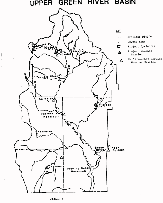
All equipment used in the project was installed in the fall of 1982 or in the spring of 1983. The 1983 progress report describes installation work and the "start-up" of the project. Experience has shown that a season is necessary for the establishment of vegetation grown in lysimeters.Figure 1 is a map showing locations of lysimeters, weather stations and other features of the upper Green River Basin. Table 1 presents lysimeter location numbers and treatment descriptions.
For the most part, activities in 1984 involved the routine collection of field data from both the lysimeters and the weather stations. Large amounts of data were collected in 1984. Within a week of bringing field data to Laramie, initial processing has usually been accomplished. Detailed comparisons and modeling will be done later.
A second activity has been the analysis of historic data from the upper Green River area. Various calculations and comparisons have been made and work plans for the completion of the project are discussed.
Funding for the research project described in this report is from the Wyoming Water Development Commission and by the Wyoming Water Research Center of the University of Wyoming.
All data discussed in this report is believed to be reliable and accurate, but should be regarded as being provisional until the project is complete and the final report has been published.
WEATHER STATION OPERATION
Introduction
Operation
The weather stations were installed in early 1983. At that time,
the
weather stations were programmed for data accumulation as shown
below:
1) total 24 hour precipitation*The mention of brand names does not imply endorsement.
2) total 24 hour solar radiation
3) maximum and minimum temperature and time of each over a 24 hour period
4) maximum and minimum relative humidity and time of each over a 24 hour period
5) average daily temperature
6) average daily relative humidity
7) total wind run each 4 hour period
8) relative humidity sampled at 4 hour intervals
9) temperature sampled at 4 hour intervals
The number and frequency of weather parameter readings being recorded allows for a maximum interval of 15 days between visits to service the stations and collect data.
The data stored on the micrologger are "dumped" onto a portable cassette tape recorder. The tape is then transported to Laramie and connected to the University computer system where the recorded data are transferred, stored, and analyzed.See the 1983 progress report for examples of climatic data accumulated using the automatic weather stations.
Beginning in October 1983 when lysimeter operations ended, the weather stations were reprogrammed for winter operation and were operated at a reduced data accumulation rate until April of 1984, (see the 1983 report for more information).
The data accumulation from the stations has been very satisfactory, during summer months with only minimal isolated problems with a few sensors. However, difficulty was encountered with extreme cold weather operation of the tape recorder used to transfer data to the UW computer and considerable winter data was lost. For this reason, the microloggers and sensors have been removed and taken to Laramie for servicing and wintertime climatic data will not be collected during 1984-1985 winter period. Wintertime data collection is not important for this study.
LYSIMETER OPERATION
The operation during the summer of 1984 was slightly modified from the operation procedures used during the summer of 1983. In 1983, the alta fescue grass and alfalfa sites were allowed to grow without being cut for the entire season. This method was used to allow the newly seeded grass and alfalfa crops to establish themselves within the lysimeters. The operation of the alta fescue grass sites was changed in 1984 to make these sites compatible with the established method for the determination of crop coefficients. To meet the requirements for establishing these crop coefficients, the alta fescue grass was clipped once every week to a height of 3 to 6 inches. Because of the difficulty in collection of the grass clippings, no record of crop yields is available for the three alta fescue grass sites. Operation of the alfalfa sites in 1984 was the same as 1983 with the exception of the frequency of harvesting. During the 1984 season, the alfalfa crop inside the lysimeter was cut at the same time, within a day or two, as the surrounding alfalfa field. This method was used to insure uniformity between the alfalfa inside the lysimeter and that in the surrounding field. The alfalfa cut from the lysimeters was then returned to the University of Wyoming to be dried, weighed and recorded.The mountain meadow grass sites and improved meadow grass sites were also operated during the 1984 season in a manner similar to the 1983 season. In 1984, one-half of these sites, four in number, were operated in a manner consistent with conditions outside the lysimeter. This method of operation includes:
A. Regular weekly irrigation.This particular method of operation shall be referred to as actual even though all the lysimeter conditions are not identical to the actual conditions that exist outside the lysimeter. The results obtained from this method will be useful in determining an estimate of the actual consumptive water use for mountain meadow and improved meadow grasses in the Green River Basin.
B. Water table depth approximately the same as the outside field.
C. Stop lysimeter irrigation when outside irrigation stops.
D. Harvest lysimeter crop when outside crop is harvested.
E. Continuously monitor soil moisture and precipitation.
The four remaining mountain meadow and improved meadow grass lysimeters were operated to simulate what we will call potential consumptive water use. Again, it must be emphasized that the use of the term "potential" in this report does not absolutely mean that all the factors that influence evapotranspiration are operating at their potential level, but only that the conditions under which these four lysimeters have been subjected approximates potential conditions which will result in a reliable estimate of potential consumptive water use for the crop involved. The potential method contains the following elements:
A. Regular weekly irrigation for entire season.Using the potential method, as described above, allows for the development of evapotranspiration (ET) equations using the concept of a reference crop which shall be used to make estimates of consumptive water use models for the Green River Basin area in the future.
B. Water table depth maintained between 3 and 4 feet.
C. Harvest lysimeter crop when outside crop is harvested.
D. Continuously monitor soil moisture and precipitation.
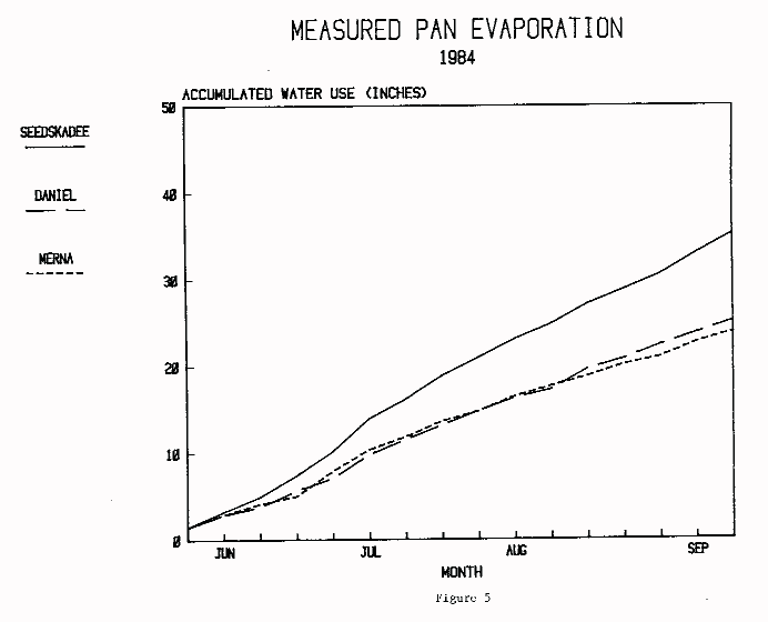
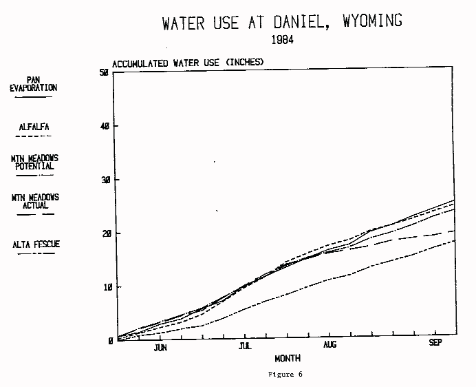
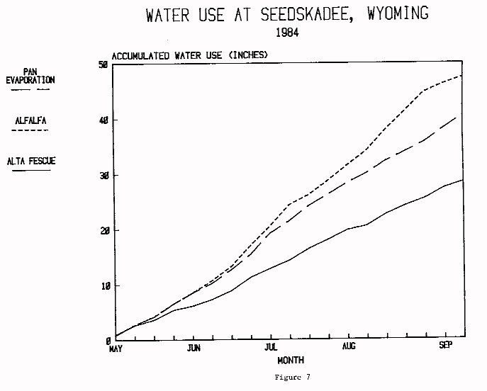
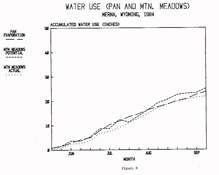
In conjunction with the development of the above mentioned ET equations, it is useful to compare the crop ET with the evaporation from a Class A evaporation pan. For this reason, four Class A pans were installed and monitored during the 1984 growing season in the Green River Basin. One pan is located at each of the following sites; Seedskadee Hay Farm, Daniel and Merna. Results from these pans are included in the following section of this report along with the lysimeter results. In addition, a pan was installed at the Rock Springs White Mountain Golf Course. Measurements for this pan were taken by the course personnel during most of the summer period.
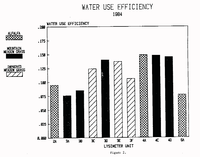
With the exception of the three alta fescue grass sites, all the lysimeter crops were harvested and yield calculations were made. This information, coupled with the water use in inches, enables the development of the water use efficiency values for each lysimeter crop. Water use efficiency is termed as the crop yield, expressed in tons per acre, per water use in inches. For this approach, it is desirable to have high yields from low amounts of applied irrigation water. Water use amounts, yields and water use efficiencies for 11 of the lysimeter crops during 1984 in the Green River Basin are shown in Table 2. A bar graph is shown in Figure 2 for use in the comparison of water use efficiencies from one crop to another and from one location to another. It is clear from Figure 2 that lysimeter 4A, located near Daniel, Wyoming, with a crop of alfalfa has the highest water use efficiency while lysimeter 3A, located near Merna, Wyoming, with a crop of mountain meadow grass has the lowest.
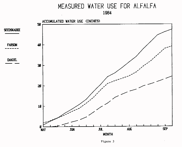
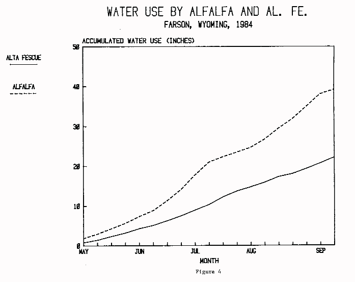
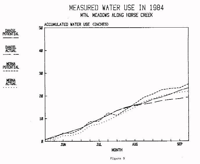
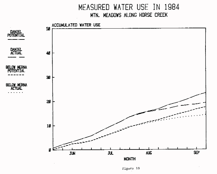
Lysimeter and pan data taken at the various sites during 1984 are shown in Figures 3 through 10. The water use data are plotted as accumulated water use beginning with the first measurements of the season. The first measurements indicate the approximate beginning of the growing season, however, there was obviously some water loss before measurements began as well as later throughout the winter season.
Results are shown for water use at four sites - Farson, Seedskadee, Daniel and Merna. Water use data are also shown to compare mountain meadow water use along Horse Creek from Daniel to Merna and to compare alfalfa water use between the three locations of Farson, Seedskadee, and Daniel. No alfalfa data were taken along Horse Creek above Daniel because alfalfa would not be expected to grow at that location.
The mountain meadow data includes two types of water use. During the early to mid portions of the growing season, all lysimeters were kept well-watered as were surrounding fields. Thus, potential water use was measured by all of the mountain meadow lysimeters. During the latter portions of the summer season, selected mountain meadow lysimeters were not irrigated. Thus, both potential and actual water use were measured during this period, with actual being defined as the water use under the drier conditions. These periods are indicated on each of the Figures. Water use for mountain meadows at Merna is plotted for individual lysimeters. At Daniel, the water use for two mountain meadow lysimeters is plotted as a single curve until differences began to appear due to the lack of irrigation on one lysimeter. The water use for mountain meadows below Merna is plotted as averages of two lysimeters for both the potential and actual water use.
Water use for both alfalfa and mountain meadows exceeded or was near pan evaporation at all sites having pan data. This indicates a high rate of vegetative water use. At Daniel, where both alfalfa and mountain meadow water use was measured, the potential rate of water use was nearly identical for the two crops.
Comparison of water use across the Basin shows that alfalfa at Seedskadee had about twice the accumulative consumptive use as alfalfa at Daniel.
DATA ANALYSIS AND MODELING
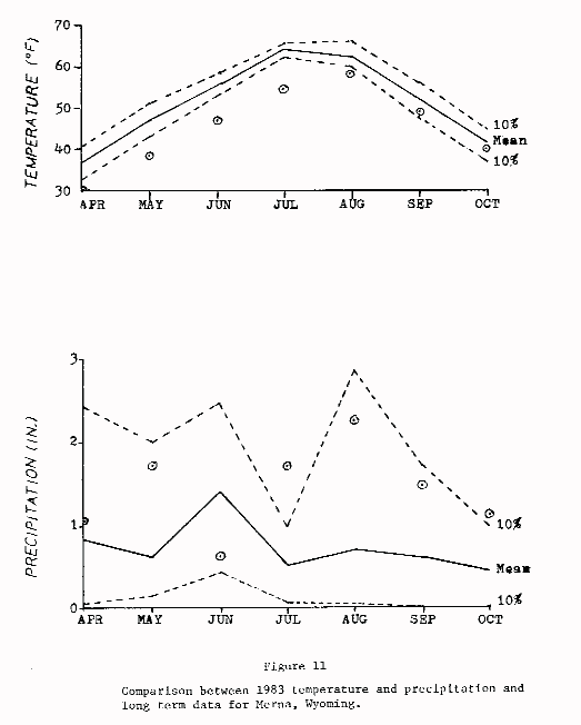
Efforts on data extrapolation for use in basin wide estimation of climatic information and consumptive use have continued. A thesis, "Estimating Monthly Temperature and Precipitation Normals at Ungaged Sites in the Upper Green River Basin" by Joan Schumaker has been completed. The use of the statistical method known as "kriging" has continued. This activity has produced a paper titled "Estimation of Climatic Variables Using Standard Modeling Techniques and Random Field Theory" by Bajusz, Shumaker, Pochop and Burman, and "Predicting Temperature and Precipitation at Ungaged Sites in the Upper Green River Basin" by Shumaker, Bajusz, Pochop and Borrelli. The papers were presented at the Third Conference on Mountain Meteorology, October 16-19, 1984 at Portland, Oregon and appear in the Proceedings of that conference.Figure 11 shows a comparison between the 1983 measured temperature and precipitation data for Merna which is in the upper Horse Creek area and averages for the same quantities. An inspection of Figure 11 shows that the 1983 air temperatures were below the 10% level of probability of receiving temperatures this low or lower except in late fall and that rainfall was above normal except in June. Similar comparisons have not been made for 1984.
It is desirable to be able to separate climatic from vegetative effects in the analysis of evapotranspiration data from the lysimeters operated in the Green River area. The Penman-Montieth model largely removes the effects of climate through the calculation of various parameters used in the Penman method and also a term representing aerodynamic resistance. The methods also calculates a crop canopy resistance which then may be explained by plant variations. A computer program making calculations for the resistance term has been prepared and carefully checked by a similar program written entirely by a graduate student. Part of the same computer model is a procedure for calculating evapotranspiration using most of the major methods used in the world at the present time.
FUTURE PLANS
Data collection from the lysimeters and weather stations will be stressed in the 1985 summer season. Only minor modifications in field procedures will be made. Weather stations will be removed from the Green River area during the winter of 1984-1985 for servicing and checkout. Minor replacements of sensor components will be made.Continuation of work on data extrapolation and analysis of data using the aerodynamic and crop resistance model of Montieth will be given priority because the initial promise of results and the fact that both approaches are new with respect to determining water requirements in a basin like the Upper Green River.
The collection of field data using lysimeters and weather stations will be a major emphasis during the growing season of 1985. According to the research contract between the Water Development Commission, the Agricultural Engineering Department and the Wyoming Water Research Center, there will be no collection of field data during the 1986 growing season. Instead, the major emphasis of the project will be the detailed analysis of data, comparisons between methods of estimating evapotranspiration and field measurements and the development and calibration of models. This work will be done during the winter of 1985 and until the contract completion on July 31, 1986. A final project report is due on November 1 of 1986 and preparation of the report will begin early in 1986.
LYSIMETER AND WEATHER STATION DESCRIPTIONS,
UPPER GREEN RIVER BASIN IN WYOMING,
AGRICULTURAL ENGINEERING DEPARTMENT, UNIVERSITY OF WYOMING
November, 1984
Identification     Type     Location         Description         Treatment
     2A            Lys.     Farson           Alfalfa
     2B             "       Farson           Alta Fescue
     3A             "       Merna            Mountain Meadow     Potential
     3B             "       Merna            Mountain Meadow     Actual
     3C             "       Horse Creek      Improved Meadow     Actual
     3D             "       Horse Creek      Mountain Meadow     Potential
     3E             "       Horse Creek      Improved Meadow     Actual
     3F             "       Horse Creek      Improved Meadow     Potential
     4A             "       Daniel           Alfalfa
     4B             "       Daniel           Alta Fescue
     4C             "       Daniel           Mountain Meadow     Potential
     4D             "       Daniel           Mountain Meadow     Actual
     6A             "       Seedskadee       Alfalfa
     6B             "       Seedskadee       Alta Fescue
      1         Climatic    Rock Springs     CR-21 Recorder
      2             "       Farson           "         "
      3             "       Merna            "         "         Evap. Pan
      4             "       Daniel           "         "           "    "
      5             "       Big Piney        "         "
      6             "       Seedskadee       "         "         Evap. Pan
      7             "       Lyman            "         "
Table 2.
| Lysimeter Location |
Site I.D. |
Crop | Operation Method |
Water Use (In) |
Crop Yield (Ton/Ac) |
Water Use Efficiency |
| Farson | 2B | Alfalfa | Potential | 38.06 | 3.60 | .095 |
| Merna | 3A | Mtn. Md. | Potential | 25.13 | 1.91 | .076 |
| Merna | 3B | Mtn. Md. | Actual | 20.76 | 1.76 | .085 |
| Horse Cr. | 3C | Imp. Md. | Actual | 11.67 | 1.45 | .124 |
| Horse Cr. | 3D | Mtn. Md. | Potential | 11.54 | 1.62 | .140 |
| Horse Cr. | 3E | Imp. Md. | Actual | 14.22 | 1.95 | .137 |
| Horse Cr. | 3F | Imp. Md. | Potential | 17.77 | 1.89 | .106 |
| Daniel | 4A | Alfalfa | Potential | 14.13 | 2.11 | .149 |
| Daniel | 4C | Mtn. Md. | Potential | 13.67 | 2.02 | .148 |
| Daniel | 4D | Mtn. Md. | Actual | 13.83 | 2.00 | .145 |
| Seedskadee | 6A | Alfalfa | Potential | 44.67 | 3.44 | .077 |
Water Resources Publications List
Water Resources Data System Library |
Water Resources Data System Homepage