| |||||||||||||||||||||||||||||||||||
| |||||||||||||||||||||||||||||||||||
DETERMINATION OF REGIONAL RELATIONSHIP
BETWEEN SNOWCOVER AND ANNUAL RUNOFF
IN WYOMING
R.W. Marrs September 1984 WWRC-84-11
Report for 1983-84 Project Year
Submitted to
Wyoming Water Research Center
University of Wyoming
Laramie, Wyoming
Submitted by
Ronald W. Marrs
Department of Geology and Geophysics
University of Wyoming
Laramie, Wyoming
September 1984
Contents of this publication have been reviewd only for editorial and grammatical correctness, not for technical accuracy. The material presented herein resulted from objective research sponsored by the Wyoming Water Research Center, however views presented reflect neither a consesus of opinion nor the views and policies of the Water Research Center or the University of Wyoming. Explicit findings and implicit interpretations of this document are the sole responsibility of the author(s).Introduction and Relevance of Project
Variations in annual runoff are a critical concern to agriculture, urban water districts, utility companies and many other resource management agencies. In Wyoming, the snowpack that accumulates in mountain areas during the winter contributes substantially to the annual runoff. Accurate estimates of the amount of water held in snowpack are essential to proper management of water and water-related resources.
Traditionally, snowpack has been monitored by selected, on-site, recording stations and periodic snowpack sampling. These techniques have been proven effective, but are subject to limitations with regard to accuracy and practicality. Recent research has demonstrated that the traditional techniques can be effectively augmented by using the periodic coverage of LANDSAT to monitor the build-up and depletion of the annual snowpack in each drainage basin (Hannaford, 1975; Rango and Salomonson, 1975; Thompson, 1975; and Washicheck and Mikesell, 1975); but, to use the satellite data effectively, estimates of area of snowpack and ground measurements must be correlated for a period of several years in order to establish a characteristic snowmelt/runoff relationship for each watershed. Once these relationships are known, accurate estimates of expected runoff can be made using the repetitive satellite coverage provided by LANDSAT. It was the purpose of this project to determine the requisite relationship between snowcover (as recorded by the satellite) and runoff (as recorded by ground stations) in each drainage basin.
This project was begun in 1983 and was supported by the USDI/OWP program through the Wyoming Water Research Center. It has been extended for its 1984-1984 project period with continued support of WWRC and USDA/USGS. Consequently, this report represents a summary of the first year's progress.
Objective of the Research
The objective of the research was to correlate measured runoff for past years with estimates of snowpack. derived from interpretations of satellite imagery obtained those same years. This correlation, to be made for each major drainage area in Wyoming, provides an empirical data base for determining projected runoff in future years. The LANDSAT imagery also provides an archival record of the snow accumulation each year. This record should prove extremely valuable for determination of fluctuations in snowpack that relate to climate change or other transient phenomena.
Background
The application of LANDSAT imagery to runoff prediction has been demonstrated by other workers. Much of the early work employing LANDSAT imagery in this application was presented at a 1975 NASA conference entitled "Operational Application of Satellite Snowcover Observations". Thompson (1975) presented results of work in which he applied the image techniques to snowcover and runoff estimation in the Little Laramie River drainage basin of southern Wyoming. He related percent snowcover to percent cumulative runoff, and found that the LANDSAT-derived snowcover data were highly correlated with cumulative runoff and that the relationship can be mathematically represented to provide a useful predictor equation for that basin. Rango and Salomonson (1975) obtained similar results for seven watersheds in the Wind River Mountains. Both groups felt that the application was successful and provided a low-cost option for improving runoff prediction capability. Yet the technique has not been applied routinely as a technique for improving water supply forecasts. In June of 1983, this project was initiated in order to compile the data base needed and to determine snowcover/runoff relationships for Wyoming watersheds.
Progress Summary
During the 1983 calendar year, inventory was completed of the University LANDSAT Image Library in order to identify scenes suitable for estimating snowcover throughout Wyoming. Suitable scenes were catalogued according to their identification numbers, dates, location (coverage), quality, and cloud cover. The catalogue now includes some 330 scenes (spanning dates from 1972 through 1983) that provide a beginning data base from which to draw snowpack information for each watershed in Wyoming. The data base is far from complete at present, and appropriate scenes are being selected to supplement the available imagery. These supplemental images are being ordered from the archives of the EROS Data Center in Sioux Falls, South Dakota, and from other agencies that have Wyoming imagery on file.
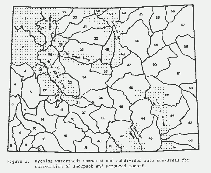
Watershed areas that are influenced by runoff from snowpack were identified and subdivided to facilitate correlation of imagery and stream flow data (Fig. 1). Location of stream-flow guaging stations were plotted (at 1:500,000 scale) and correlated with watershed subdivisions. Stations were selected and streamflow data retrieved for appropriate dated in order to determine relationships between snowpack and runoff for each watershed.
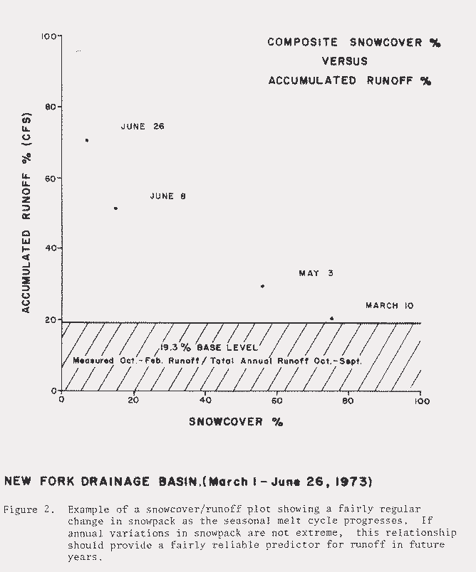
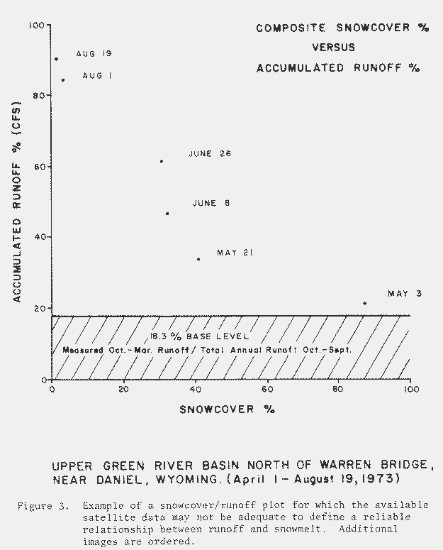
Each LANDSAT image is interpreted to determine percent snowcover in each watershed subdivision. The interpretation is aided by video density analysis and areas are estimated using the video electronic planimeter. Area measurements (snowcover) are plotted relative to cumulative runoff (Figs. 2 and 3) to establish relationships that can subsequently be used to predict annual runoff, rates of runoff, and timing of peak runoff using the satellite imagery as the prime indicator. Relationships between runoff and snowcover derived empirically by correlation of data and imagery over a period of several years are tested by predicting runoff for other years and checking the results by correlation with measured runoff. Each watershed is treated separately and each year's data provides opportunity to improve the predicator relationship. Each relationship is refined annually as additional satellite data and streamflow data become available.
The work on this program during the 1983-1984 academic year shows that the technique is quite effective in mountainous watersheds where permanent snowpack is a major factor in spring runoff. The technique works best in the areas that are least accessible and are of greatest interest to water resource managers, so the results provide a very important tool for water management.
The first years'work has resulted in a complete inventory of useful imagery currently in the image library of the remote sensing laboratory. Images have been evaluated and runoff data collected for most drainage areas In western Wyoming. Additional LANDSAT scenes have been selected for several areas and will be ordered in September. Runoff data have been obtained for most of the drainage basins and we are completing first level plots for the areas that have five or more dates of useful coverage. Overall progress for each area is summarized in Table I.
Bill Small, our graduate research assistant, resigned in July, 1984, and the work proceeded very slowly during the late summer for lack of manpower. Cheryl Jaworowski was hired to replace Bill Small as of September 1, 1984. The work is now proceeding at a normal pace and should be quickly caught up pending appointment of a second graduate assistant in mid-September.
REFERENCES
Hannaford, J.F., 1975, Interpretation of the snowcover from satellite imagery for use in water supply forecasts in the Sierra Nevada: NASA Workshop on Operational Applications of Satellite Snowcover Observations, NASA SP-301, p. 39-52.
Rango, A., and Salomonson, V.V., 1975, Employment of satellite snowcover observations for improving seasonal runoff estimates: NASA Workshop on Operational Applications of Satellite Snowcover Observations, NASA SP-391, p. 157-174.
Thompson, A.G., 1975, Utilization of LANDSAT monitoring capabilities for snowcover depletion analysis: NASA Workshop on Operational Applications of Satellite Snowcover Observations, NASA SP-291, p. 113-128.
Washicheck, J.N., and Mikesell, T., 1975, Operational applications of satellite snowcover observations In the Rio Grande drainage of Colorado: NASA Workshop on Operational Applications of Satellite Snowcover Observations, NASA SP-391, p. 53-70.
| Area Number | Area Name | Imagery Available | Drainage Mask Constructed | Snowcover Measured | Streamflow Data Acquired | Runoff/Snowpack Plots Drafted | Remarks |
| 1 | Yellowstone River | X | |||||
| 2 | Upper Snake River | X | |||||
| 3 | Hoback River | X | X | X | |||
| 4 | Salt River | X | X | ||||
| 5 | Piney River | X | X | ||||
| 6 | North Bear River | X | |||||
| 7 | Fontenelle | X | X | X | X | X | |
| 8 | South Bear River | X | |||||
| 9 | Muddy Creek | X | |||||
| 10 | Ham's Fork | X | |||||
| 11 | Black's Fork | X | |||||
| 12 | Henry's Fork | X | |||||
| 13 | Flaming Gorge | X | X | ||||
| 14 | Middle Green River | X | X | X | X | X | |
| 15 | Bitter Creek | X | |||||
| 16 | Red Desert | X | X | ||||
| 17 | Big Sandy | X | X | X | |||
| 18 | Little Sandy | X | X | X | X | X | |
| 19 | Upper Big Sandy | X | X | X | X | X | |
| 20 | Temple Peak | X | X | X | X | X | |
| 21 | South Pass | X | |||||
| 22 | New Fork | X | X | X | X | X | |
| 23 | Popo Agie | X | |||||
| 24 | Green River Bend | X | X | X | X | X | |
| 25 | Middle Wind River | X | |||||
| 26 | Upper Wind River | X | |||||
| 27 | Upper Shoshone | X | |||||
| 28 | Wood River | X | |||||
| 29 | Clark's Fork | X | |||||
| 30 | Lower Bighorn R. | X | |||||
| 31 | Greybull River | X | |||||
| 32 | Middle Bighorn R. | X | |||||
| 33 | Upper Bighorn R. | X | |||||
| 34 | Lower Wind River | X | |||||
| 35 | Badwater River | X | |||||
| 36 | Sweetwater River | X |
Water Resources Publications List
Water Resources Data System Library |
Water Resources Data System Homepage