Wyoming Water Resources Center

|
RESEARCH BRIEFS Wyoming Water Resources Center |
|
Investigators: Chris M. Goertler, Wyoming Water Resources Center; Thomas A. Wesche, Wyoming Water Resources Center and Department of Rangeland Ecology and Watershed Management; and Quentin Skinner, Department of Rangeland Ecology and Watershed Management, University of Wyoming.
Purpose: The value of healthy stream channels and their associated
riparian zones is widely recognized, yet little scientific information is
available quantifying the amount of suspended sediment deposited within these
areas. This is especially important as suspended sediment is considered a major
nonpoint source pollutant in Wyoming streams. Consequently, this research was
conducted on Muddy Creek, a Wyoming cold-desert perennial stream considered by
the U.S. Environmental Protection Agency as a major contributor
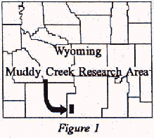 of sediment to
downstream systems in the Upper Colorado River Basin (Figure 1). The research
goal of this study was to compare streamflow and suspended sediment transport
through degraded, improved, and improving stream channel segments of Muddy Creek
where each supported different types of riparian vegetation.
of sediment to
downstream systems in the Upper Colorado River Basin (Figure 1). The research
goal of this study was to compare streamflow and suspended sediment transport
through degraded, improved, and improving stream channel segments of Muddy Creek
where each supported different types of riparian vegetation.
Background: Research began in 1983 with funding from the U.S.D.A. Cooperative Research Service, Wyoming Southwestern Livestock Grazing Board, U.S. Bureau of Land Management (BLM), Wyoming Water Development Commission, and Wyoming Water Resources Center. Our research was part of an overall program designed to evaluate differences in riparian vegetation and groundwater storage found in the selected degraded, improved, and improving stream channel segments. Early in this study, 14 different user groups (state agencies, federal agencies, landowners, and the University of Wyoming) signed a Memorandum of Understanding to provide project advice and begin a goal setting process for managing the Muddy Creek watershed. The BLM identified our research area as being of national importance and named it a Riparian Zone Demonstration Area.
Methods: The Wyoming Water Resources Center established the hydrologic
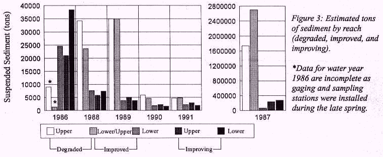
and suspended sediment transport monitoring network within the ten mile long
Riparian Zone Demonstration Area. Data were collected at five stations
established above and below the degraded, improved, and improving stream
segments to estimate surface water discharge and suspended sediment load for
each of these areas. These data were then compared to help characterize
sediment transport within: a) the degraded segment (a U-shaped channel
without a well-developed floodplain where little or no riparian vegetation
grew); b) improved segment (a shallow and braided channel supporting a
relatively level one-half mile wide grass and willow covered riparian zone
created by man-made diversion dikes); and c) improving segment (a
single channel with floodplains along each bank where small, wire dams were
placed to promote sediment deposition, increase the growth of riparian grass
and willow, stabilize the channel, and add streamflow to groundwater supplies).
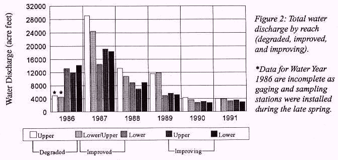
We estimate that 10,000 acre feet of streamflow in Water Year 1987 were stored and then lost to the groundwater supply, and/or to evapotranspiration, within the improved segment because contribution of this water to late summer streamflow was not evident (Figure 2). Periods of zero flow were recorded during the late summer and fall in the drier water years and most prevalent through the degraded segment. Water stored during low flow years behind wire dams in the improving segment remained available for use by both wildlife and livestock although Muddy Creek above and below this segment was dry.
Continued Activity on Muddy Creek: University research initiated by the 1983 group was discontinued in 1991, at which time the Little Snake River Conservation District led an effort to form a Muddy Creek Cooperative Resource Management (CRM) program. This active program s goal is to promote best practices for managing the Muddy Creek watershed. All user groups and interested parties of the CRM continue to focus their attention on promoting best management of the headwater uplands and riparian zones of Muddy Creek.
Publications:
Goertler, C.M. 1992.Sediment Dynamics Within
Channel and Riparian Zone Types Along a Cold-Desert Wyoming Stream. MS
Thesis, University of Wyoming, Laramie, WY. 205 pp.
 |
RB95-01 |
Research Briefs List
Water Resources Data System Library |
Water Resources Data System Homepage