Wyoming Water Resources Center

|
RESEARCH BRIEFS Wyoming Water Resources Center |
|
Investigators: Robert J. Henszey, Wyoming Water Resources Center, University of Wyoming; Quentin D. Skinner, Department of Range Management, University of Wyoming; and Thomas A. Wesche, Wyoming Water Resources Center and Department of Range Management, University of Wyoming
Purpose: The value of healthy riparian wetlands to wildlife, fisheries, agriculture, and for nonpoint pollution control is well established, yet few quantitative data are available relating the underlying hydrology to the riparian plant species that support these wetlands. We initiated our research because future riparian mitigation projects may require more specific hydrologic information to maintain healthy riparian plant communities than were previously available. The objectives were to detail the surface and groundwater hydrology of four montane meadow types in southeastern Wyoming, and to develop depth-to-groundwater relationships for an assemblage of wetland sedges (Carex spp.), tufted hairgrass (Deschampsia cespitosa [L.] Beauv.), and slimstem reedgrass (Calamagrostis neglecta [Ehrh.] Gaertn.).
Methods: The study area was located 45 km west of Cheyenne, Wyoming,
in the Medicine Bow National Forest. Hydrologic and biologic data were
collected from both natural ephemeral watercourses, and an ephemeral watercourse
 converted to a perennial stream with streamflow augmentation. Depth-to-
groundwater hydrographs and duration curves were used to describe the
water-level regime for dry, moist, moist-wet, and wet meadows. The hydrologic
regimes were related to the plants with depth-to-groundwater suitability curves.
These curves were adapted from the Habitat Suitability Index (HSI) models used
by the U.S. Fish and Wildlife Service, and suggest the expected plant response
(biomass and density) to groundwater depths that occur at a specific level or
above for 10, 50 and 90% (D10, D50, D90) of the growing season.
converted to a perennial stream with streamflow augmentation. Depth-to-
groundwater hydrographs and duration curves were used to describe the
water-level regime for dry, moist, moist-wet, and wet meadows. The hydrologic
regimes were related to the plants with depth-to-groundwater suitability curves.
These curves were adapted from the Habitat Suitability Index (HSI) models used
by the U.S. Fish and Wildlife Service, and suggest the expected plant response
(biomass and density) to groundwater depths that occur at a specific level or
above for 10, 50 and 90% (D10, D50, D90) of the growing season.
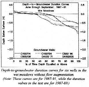
Results: Mean depth-to-groundwater differed between meadow types. Wet meadows without flow augmentation had groundwater levels closer to the surface (D10 = -0.05 m, D50 = -0.44 m, D90 = -0.65 m) than the other three meadow types without flow augmentation. Dry meadows without flow augmentation had the deepest groundwater levels for D10(-0.98 m) and D50(-1.22 m), while the moist meadows had the deepest groundwater levels for D90(-1.58 m). Streamflow augmentation elevated the natural groundwater levels so that at least 0.03-0.06 m of standing water occurred for 10% of the June through September growing season in the moist, moist-wet, and wet meadows.
 The optimum depth-to-groundwater for sedge biomass was a nearly constant
0.15 m (D10 to D90) of standing water, while the optimum depth-to-groundwater
for sedge density was 0.18 m (D10), 0.43 ± 0.26 m (D50 ± 95% CI), and
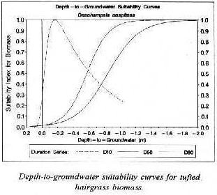
0.76 ± 0.45 m (D90 ± 95% CI) below the surface. Tufted hairgrass
response was optimized when the depth-to-groundwater was between 0.17 and
0.29 m for D10, deeper than 1.23 m for D50, and deeper than 1.79 m for D90.
The relationship between slimstem reedgrass biomass and the
depth-to-groundwater was too poor to develop suitability curves, but slimstem
reedgrass density appeared to decrease if the groundwater depths were
shallower than 1.05 m for D10, 1.34 m for D50, and 1.81 m for D90.
The optimum depth-to-groundwater for sedge biomass was a nearly constant
0.15 m (D10 to D90) of standing water, while the optimum depth-to-groundwater
for sedge density was 0.18 m (D10), 0.43 ± 0.26 m (D50 ± 95% CI), and
0.76 ± 0.45 m (D90 ± 95% CI) below the surface. Tufted hairgrass
response was optimized when the depth-to-groundwater was between 0.17 and
0.29 m for D10, deeper than 1.23 m for D50, and deeper than 1.79 m for D90.
The relationship between slimstem reedgrass biomass and the
depth-to-groundwater was too poor to develop suitability curves, but slimstem
reedgrass density appeared to decrease if the groundwater depths were
shallower than 1.05 m for D10, 1.34 m for D50, and 1.81 m for D90.
Future Research: The depth-to-groundwater duration and suitability curves should be useful for designing constructed riparian wetlands and for predicting plant response to altered groundwater levels caused by modified flow regimes. Future research will examine these issues, and further test the depth-to-groundwater suitability curves by examining the plant response under controlled conditions in greenhouse lysimeters.
Publications:
Henszey, R.J. 1993. Riparian zone changes caused
by streamflow augmentation. Ph.D. Dissertation. University of Wyoming,
Laramie, WY. 120 pp.
Henszey, R.J. 1991. A simple, inexpensive device for measuring shallow groundwater levels. Journal of Soil and Water Conservation 46(4):304-306.
Henszey, R.J., Q.D. Skinner, and T.A. Wesche. 1991. Response of montane meadow vegetation after two years of streamflow augmentation. Regulated Rivers: Research and Management 6:29-38.
Wyoming Water Resources Center
P.O. Box 3067, University Station
Laramie, WY 82071-3067
(307) 766-2143
Fax: (307) 766-3718
 |
RB94-01 |
Research Briefs List
Water Resources Data System Library |
Water Resources Data System Homepage